You are here: Home > Network List > TA - USArray Transportable Network (new EarthScope stations) Stations List
> Station R60A Leonardtown, MD, USA > Earthquake Result Viewer
R60A Leonardtown, MD, USA - Earthquake Result Viewer
| Earthquake location: |
Rat Islands, Aleutian Islands |
| Earthquake latitude/longitude: |
51.8/178.8 |
| Earthquake time(UTC): |
2014/06/23 (174) 20:53:09 GMT |
| Earthquake Depth: |
108 km |
| Earthquake Magnitude: |
7.9 MWW, 7.1 MI, 7.9 MWC |
| Earthquake Catalog/Contributor: |
NEIC PDE/NEIC COMCAT |
|
| Network: |
TA USArray Transportable Network (new EarthScope stations) |
| Station: |
R60A Leonardtown, MD, USA |
| Lat/Lon: |
38.26 N/76.58 W |
| Elevation: |
33 m |
|
| Distance: |
68.9 deg |
| Az: |
54.704 deg |
| Baz: |
319.918 deg |
| Ray Param: |
0.05571328 |
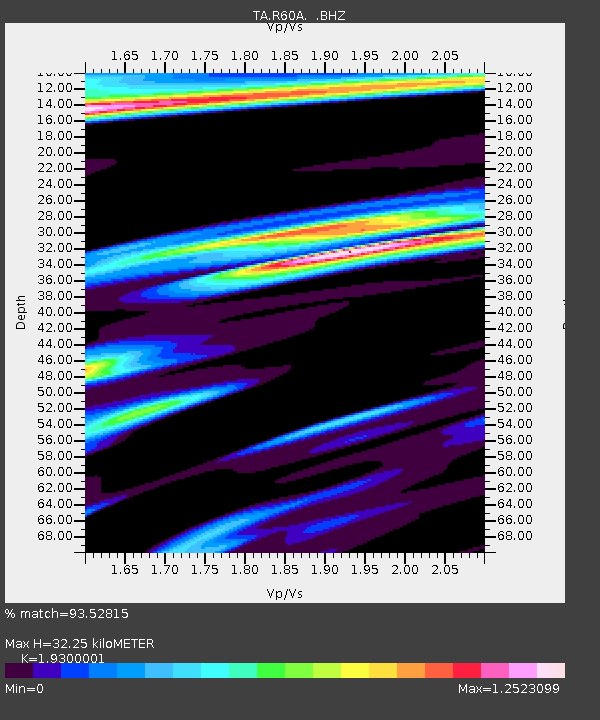
| Estimated Moho Depth: |
32.25 km |
| Estimated Crust Vp/Vs: |
1.93 |
| Assumed Crust Vp: |
6.419 km/s |
| Estimated Crust Vs: |
3.326 km/s |
| Estimated Crust Poisson's Ratio: |
0.32 |
|
| Radial Match: |
93.52815 % |
| Radial Bump: |
400 |
| Transverse Match: |
85.35215 % |
| Transverse Bump: |
400 |
| SOD ConfigId: |
739768 |
| Insert Time: |
2014-07-07 21:57:38.817 +0000 |
| GWidth: |
2.5 |
| Max Bumps: |
400 |
| Tol: |
0.001 |
|
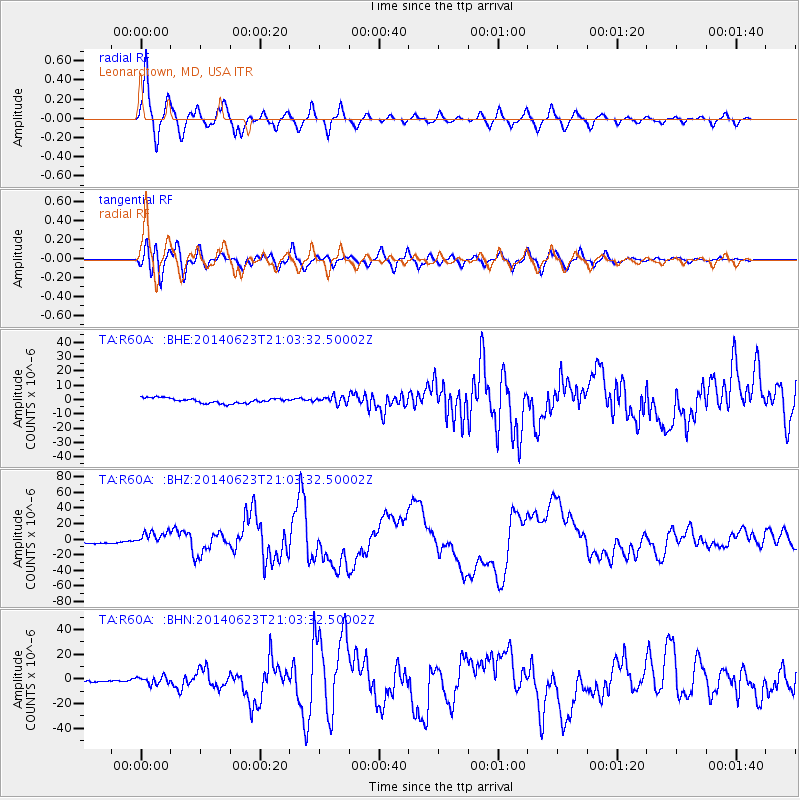
Signal To Noise
| Channel | StoN | STA | LTA |
| TA:R60A: :BHZ:20140623T21:03:32.50002Z | 3.1838782 | 8.100153E-6 | 2.544115E-6 |
| TA:R60A: :BHN:20140623T21:03:32.50002Z | 3.6982675 | 3.1105328E-6 | 8.4107836E-7 |
| TA:R60A: :BHE:20140623T21:03:32.50002Z | 1.4867398 | 2.5533257E-6 | 1.7173993E-6 |
| Arrivals |
| Ps | 4.8 SECOND |
| PpPs | 14 SECOND |
| PsPs/PpSs | 19 SECOND |


