You are here: Home > Network List > II - Global Seismograph Network (GSN - IRIS/IDA) Stations List
> Station WRAB Tennant Creek, NT, Australia > Earthquake Result Viewer
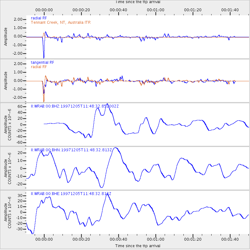
WRAB Tennant Creek, NT, Australia - Earthquake Result Viewer
*The percent match for this event was below the threshold and hence no stack was calculated.
| Earthquake location: |
Near East Coast Of Kamchatka |
| Earthquake latitude/longitude: |
54.5/162.3 |
| Earthquake time(UTC): |
1997/12/05 (339) 11:37:09 GMT |
| Earthquake Depth: |
33 km |
| Earthquake Magnitude: |
5.6 MB |
| Earthquake Catalog/Contributor: |
WHDF/NEIC |
|
| Network: |
II Global Seismograph Network (GSN - IRIS/IDA) |
| Station: |
WRAB Tennant Creek, NT, Australia |
| Lat/Lon: |
19.93 S/134.36 E |
| Elevation: |
366 m |
|
| Distance: |
77.9 deg |
| Az: |
206.812 deg |
| Baz: |
16.234 deg |
| Ray Param: |
$rayparam |
*The percent match for this event was below the threshold and hence was not used in the summary stack. |
|
| Radial Match: |
69.87225 % |
| Radial Bump: |
400 |
| Transverse Match: |
67.66979 % |
| Transverse Bump: |
400 |
| SOD ConfigId: |
4480 |
| Insert Time: |
2010-03-01 23:25:49.966 +0000 |
| GWidth: |
2.5 |
| Max Bumps: |
400 |
| Tol: |
0.001 |
|
Signal To Noise
| Channel | StoN | STA | LTA |
| II:WRAB:00:BHN:19971205T11:48:32.813Z | 4.90683 | 2.2813902E-5 | 4.649418E-6 |
| II:WRAB:00:BHE:19971205T11:48:32.813Z | 2.0725868 | 2.8141067E-5 | 1.3577752E-5 |
| II:WRAB:00:BHZ:19971205T11:48:32.852002Z | 3.6833365 | 6.0858907E-5 | 1.6522767E-5 |
| Arrivals |
| Ps | |
| PpPs | |
| PsPs/PpSs | |


