You are here: Home > Network List > TA - USArray Transportable Network (new EarthScope stations) Stations List
> Station T53A Wise, VA, USA > Earthquake Result Viewer
T53A Wise, VA, USA - Earthquake Result Viewer

| Earthquake location: |
Rat Islands, Aleutian Islands |
| Earthquake latitude/longitude: |
51.8/178.8 |
| Earthquake time(UTC): |
2014/06/23 (174) 20:53:09 GMT |
| Earthquake Depth: |
108 km |
| Earthquake Magnitude: |
7.9 MWW, 7.1 MI, 7.9 MWC |
| Earthquake Catalog/Contributor: |
NEIC PDE/NEIC COMCAT |
|
| Network: |
TA USArray Transportable Network (new EarthScope stations) |
| Station: |
T53A Wise, VA, USA |
| Lat/Lon: |
36.98 N/82.54 W |
| Elevation: |
818 m |
|
| Distance: |
66.8 deg |
| Az: |
59.462 deg |
| Baz: |
318.091 deg |
| Ray Param: |
0.057102397 |
| Estimated Moho Depth: |
44.25 km |
| Estimated Crust Vp/Vs: |
1.77 |
| Assumed Crust Vp: |
6.476 km/s |
| Estimated Crust Vs: |
3.654 km/s |
| Estimated Crust Poisson's Ratio: |
0.27 |
|
| Radial Match: |
97.939064 % |
| Radial Bump: |
359 |
| Transverse Match: |
70.08562 % |
| Transverse Bump: |
400 |
| SOD ConfigId: |
739768 |
| Insert Time: |
2014-07-07 21:58:40.277 +0000 |
| GWidth: |
2.5 |
| Max Bumps: |
400 |
| Tol: |
0.001 |
|
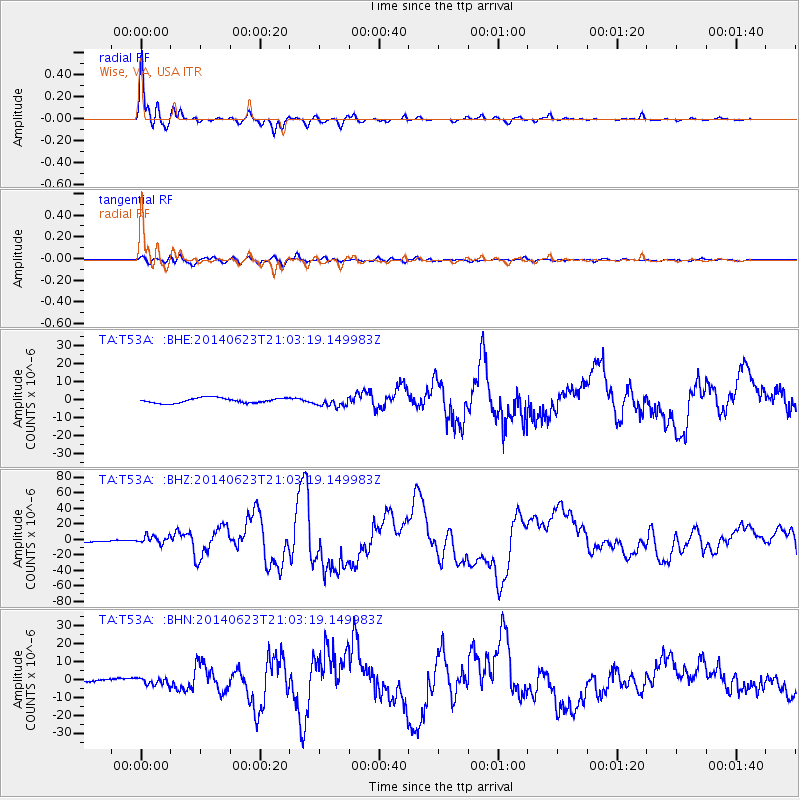
Signal To Noise
| Channel | StoN | STA | LTA |
| TA:T53A: :BHZ:20140623T21:03:19.149983Z | 4.578011 | 4.9181062E-6 | 1.0742889E-6 |
| TA:T53A: :BHN:20140623T21:03:19.149983Z | 2.8678105 | 1.987334E-6 | 6.9297954E-7 |
| TA:T53A: :BHE:20140623T21:03:19.149983Z | 1.9290992 | 2.6484104E-6 | 1.3728742E-6 |
| Arrivals |
| Ps | 5.5 SECOND |
| PpPs | 18 SECOND |
| PsPs/PpSs | 24 SECOND |


