You are here: Home > Network List > TA - USArray Transportable Network (new EarthScope stations) Stations List
> Station U57A Blanch, NC, USA > Earthquake Result Viewer
U57A Blanch, NC, USA - Earthquake Result Viewer
| Earthquake location: |
Rat Islands, Aleutian Islands |
| Earthquake latitude/longitude: |
51.8/178.8 |
| Earthquake time(UTC): |
2014/06/23 (174) 20:53:09 GMT |
| Earthquake Depth: |
108 km |
| Earthquake Magnitude: |
7.9 MWW, 7.1 MI, 7.9 MWC |
| Earthquake Catalog/Contributor: |
NEIC PDE/NEIC COMCAT |
|
| Network: |
TA USArray Transportable Network (new EarthScope stations) |
| Station: |
U57A Blanch, NC, USA |
| Lat/Lon: |
36.43 N/79.34 W |
| Elevation: |
178 m |
|
| Distance: |
68.9 deg |
| Az: |
57.767 deg |
| Baz: |
319.355 deg |
| Ray Param: |
0.055732526 |
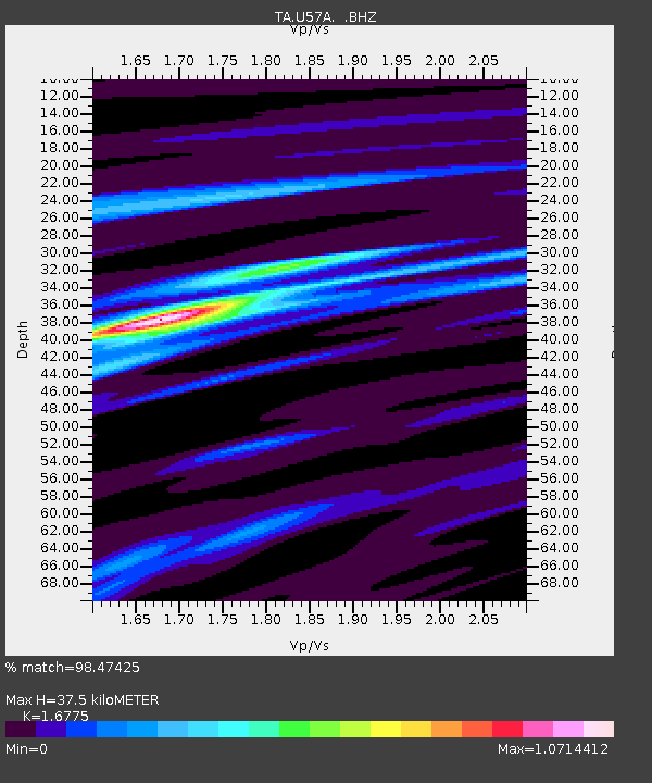
| Estimated Moho Depth: |
37.5 km |
| Estimated Crust Vp/Vs: |
1.68 |
| Assumed Crust Vp: |
6.419 km/s |
| Estimated Crust Vs: |
3.827 km/s |
| Estimated Crust Poisson's Ratio: |
0.22 |
|
| Radial Match: |
98.47425 % |
| Radial Bump: |
249 |
| Transverse Match: |
85.87111 % |
| Transverse Bump: |
369 |
| SOD ConfigId: |
739768 |
| Insert Time: |
2014-07-07 21:59:25.992 +0000 |
| GWidth: |
2.5 |
| Max Bumps: |
400 |
| Tol: |
0.001 |
|

Signal To Noise
| Channel | StoN | STA | LTA |
| TA:U57A: :BHZ:20140623T21:03:32.324971Z | 7.4086456 | 4.305703E-6 | 5.8117274E-7 |
| TA:U57A: :BHN:20140623T21:03:32.324971Z | 2.082631 | 1.5460561E-6 | 7.4235714E-7 |
| TA:U57A: :BHE:20140623T21:03:32.324971Z | 2.3400733 | 1.8740648E-6 | 8.008573E-7 |
| Arrivals |
| Ps | 4.1 SECOND |
| PpPs | 15 SECOND |
| PsPs/PpSs | 19 SECOND |


