You are here: Home > Network List > TA - USArray Transportable Network (new EarthScope stations) Stations List
> Station U59A Littleton, NC, USA > Earthquake Result Viewer
U59A Littleton, NC, USA - Earthquake Result Viewer
| Earthquake location: |
Rat Islands, Aleutian Islands |
| Earthquake latitude/longitude: |
51.8/178.8 |
| Earthquake time(UTC): |
2014/06/23 (174) 20:53:09 GMT |
| Earthquake Depth: |
108 km |
| Earthquake Magnitude: |
7.9 MWW, 7.1 MI, 7.9 MWC |
| Earthquake Catalog/Contributor: |
NEIC PDE/NEIC COMCAT |
|
| Network: |
TA USArray Transportable Network (new EarthScope stations) |
| Station: |
U59A Littleton, NC, USA |
| Lat/Lon: |
36.35 N/77.79 W |
| Elevation: |
99 m |
|
| Distance: |
69.8 deg |
| Az: |
56.807 deg |
| Baz: |
319.928 deg |
| Ray Param: |
0.055159733 |
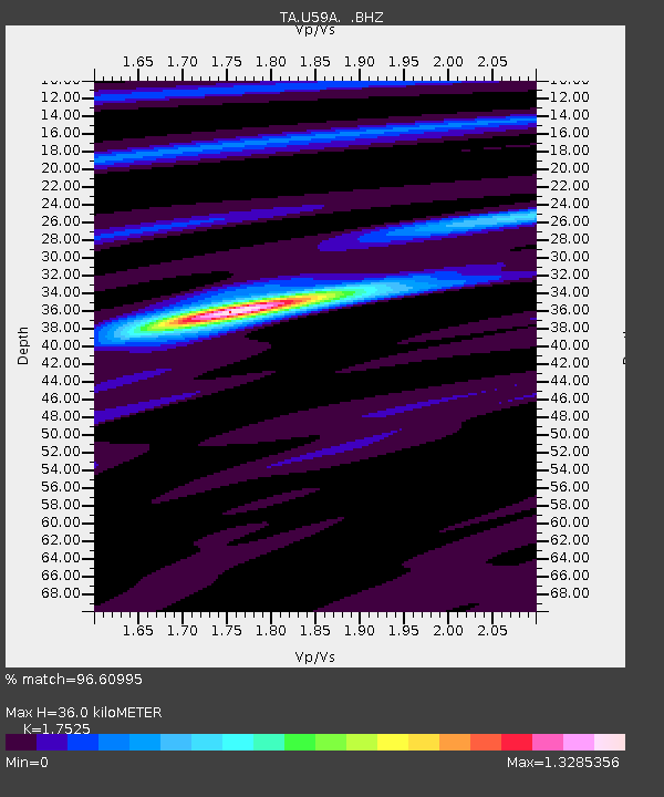
| Estimated Moho Depth: |
36.0 km |
| Estimated Crust Vp/Vs: |
1.75 |
| Assumed Crust Vp: |
6.565 km/s |
| Estimated Crust Vs: |
3.746 km/s |
| Estimated Crust Poisson's Ratio: |
0.26 |
|
| Radial Match: |
96.60995 % |
| Radial Bump: |
273 |
| Transverse Match: |
83.60486 % |
| Transverse Bump: |
395 |
| SOD ConfigId: |
739768 |
| Insert Time: |
2014-07-07 21:59:32.711 +0000 |
| GWidth: |
2.5 |
| Max Bumps: |
400 |
| Tol: |
0.001 |
|
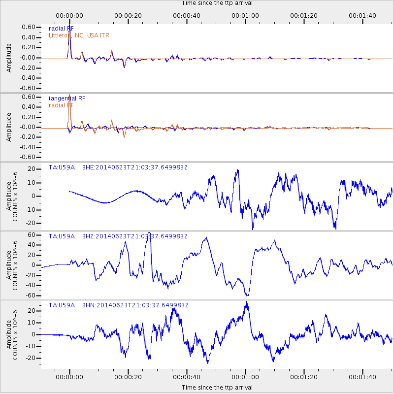
Signal To Noise
| Channel | StoN | STA | LTA |
| TA:U59A: :BHZ:20140623T21:03:37.649983Z | 1.3811369 | 6.2607296E-6 | 4.533026E-6 |
| TA:U59A: :BHN:20140623T21:03:37.649983Z | 6.368277 | 1.8978781E-6 | 2.9802064E-7 |
| TA:U59A: :BHE:20140623T21:03:37.649983Z | 1.1163044 | 3.3677013E-6 | 3.0168308E-6 |
| Arrivals |
| Ps | 4.3 SECOND |
| PpPs | 15 SECOND |
| PsPs/PpSs | 19 SECOND |


