You are here: Home > Network List > TA - USArray Transportable Network (new EarthScope stations) Stations List
> Station V60A Jim Taylor Road, Stokes, NC, USA > Earthquake Result Viewer
V60A Jim Taylor Road, Stokes, NC, USA - Earthquake Result Viewer
| Earthquake location: |
Rat Islands, Aleutian Islands |
| Earthquake latitude/longitude: |
51.8/178.8 |
| Earthquake time(UTC): |
2014/06/23 (174) 20:53:09 GMT |
| Earthquake Depth: |
108 km |
| Earthquake Magnitude: |
7.9 MWW, 7.1 MI, 7.9 MWC |
| Earthquake Catalog/Contributor: |
NEIC PDE/NEIC COMCAT |
|
| Network: |
TA USArray Transportable Network (new EarthScope stations) |
| Station: |
V60A Jim Taylor Road, Stokes, NC, USA |
| Lat/Lon: |
35.76 N/77.26 W |
| Elevation: |
8.0 m |
|
| Distance: |
70.5 deg |
| Az: |
56.857 deg |
| Baz: |
320.256 deg |
| Ray Param: |
0.05468183 |
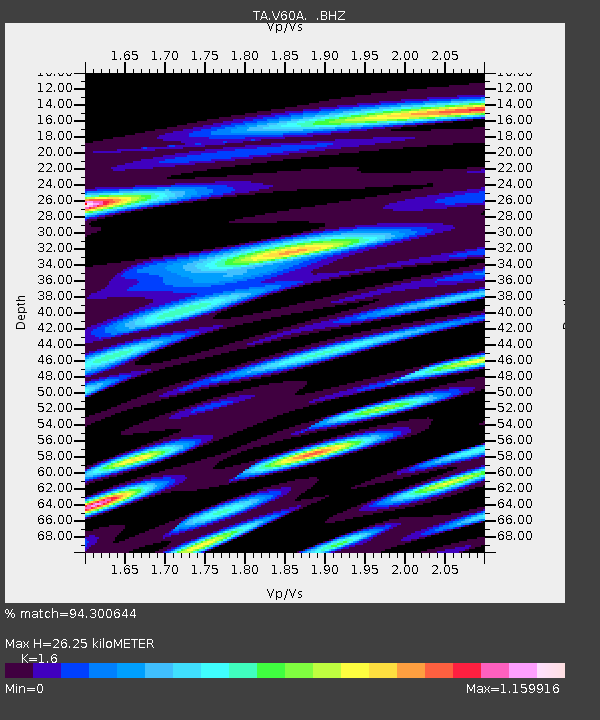
| Estimated Moho Depth: |
26.25 km |
| Estimated Crust Vp/Vs: |
1.60 |
| Assumed Crust Vp: |
6.565 km/s |
| Estimated Crust Vs: |
4.103 km/s |
| Estimated Crust Poisson's Ratio: |
0.18 |
|
| Radial Match: |
94.300644 % |
| Radial Bump: |
400 |
| Transverse Match: |
67.219925 % |
| Transverse Bump: |
400 |
| SOD ConfigId: |
739768 |
| Insert Time: |
2014-07-07 22:00:45.746 +0000 |
| GWidth: |
2.5 |
| Max Bumps: |
400 |
| Tol: |
0.001 |
|
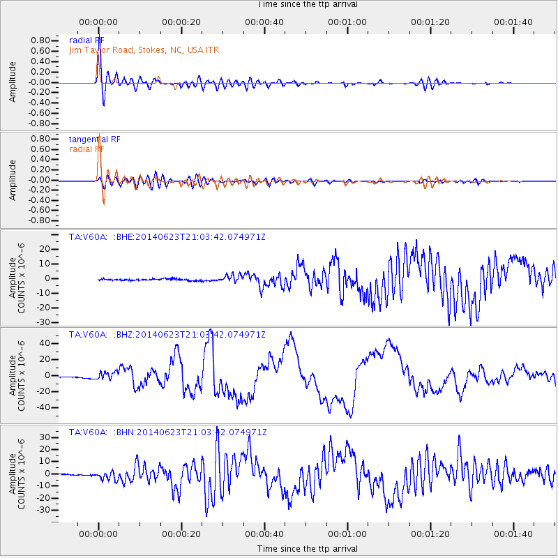
Signal To Noise
| Channel | StoN | STA | LTA |
| TA:V60A: :BHZ:20140623T21:03:42.074971Z | 3.7409456 | 4.932513E-6 | 1.3185204E-6 |
| TA:V60A: :BHN:20140623T21:03:42.074971Z | 3.7653515 | 3.5029025E-6 | 9.3029894E-7 |
| TA:V60A: :BHE:20140623T21:03:42.074971Z | 4.6343102 | 2.4618769E-6 | 5.312283E-7 |
| Arrivals |
| Ps | 2.5 SECOND |
| PpPs | 10.0 SECOND |
| PsPs/PpSs | 12 SECOND |


