You are here: Home > Network List > II - Global Seismograph Network (GSN - IRIS/IDA) Stations List
> Station WRAB Tennant Creek, NT, Australia > Earthquake Result Viewer
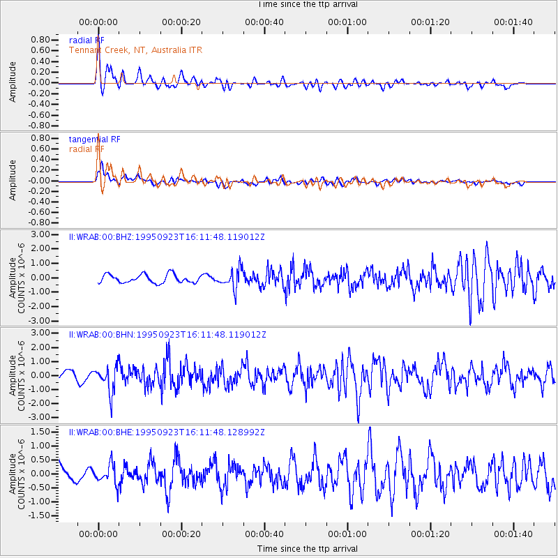
WRAB Tennant Creek, NT, Australia - Earthquake Result Viewer
*The percent match for this event was below the threshold and hence no stack was calculated.
| Earthquake location: |
Southern Sumatra, Indonesia |
| Earthquake latitude/longitude: |
-5.7/103.9 |
| Earthquake time(UTC): |
1995/09/23 (266) 16:05:50 GMT |
| Earthquake Depth: |
56 km |
| Earthquake Magnitude: |
5.8 MB, 6.2 UNKNOWN, 6.0 MW |
| Earthquake Catalog/Contributor: |
WHDF/NEIC |
|
| Network: |
II Global Seismograph Network (GSN - IRIS/IDA) |
| Station: |
WRAB Tennant Creek, NT, Australia |
| Lat/Lon: |
19.93 S/134.36 E |
| Elevation: |
366 m |
|
| Distance: |
32.8 deg |
| Az: |
118.372 deg |
| Baz: |
291.46 deg |
| Ray Param: |
$rayparam |
*The percent match for this event was below the threshold and hence was not used in the summary stack. |
|
| Radial Match: |
65.97412 % |
| Radial Bump: |
400 |
| Transverse Match: |
64.62195 % |
| Transverse Bump: |
400 |
| SOD ConfigId: |
4480 |
| Insert Time: |
2010-03-01 23:25:56.404 +0000 |
| GWidth: |
2.5 |
| Max Bumps: |
400 |
| Tol: |
0.001 |
|
Signal To Noise
| Channel | StoN | STA | LTA |
| II:WRAB:00:BHN:19950923T16:11:48.119012Z | 2.7560346 | 9.3127375E-7 | 3.3790351E-7 |
| II:WRAB:00:BHE:19950923T16:11:48.128992Z | 1.3041255 | 3.5118018E-7 | 2.6928404E-7 |
| II:WRAB:00:BHZ:19950923T16:11:48.119012Z | 2.308419 | 6.6852255E-7 | 2.896019E-7 |
| Arrivals |
| Ps | |
| PpPs | |
| PsPs/PpSs | |


