You are here: Home > Network List > IU - Global Seismograph Network (GSN - IRIS/USGS) Stations List
> Station PMG Port Moresby, New Guinea > Earthquake Result Viewer
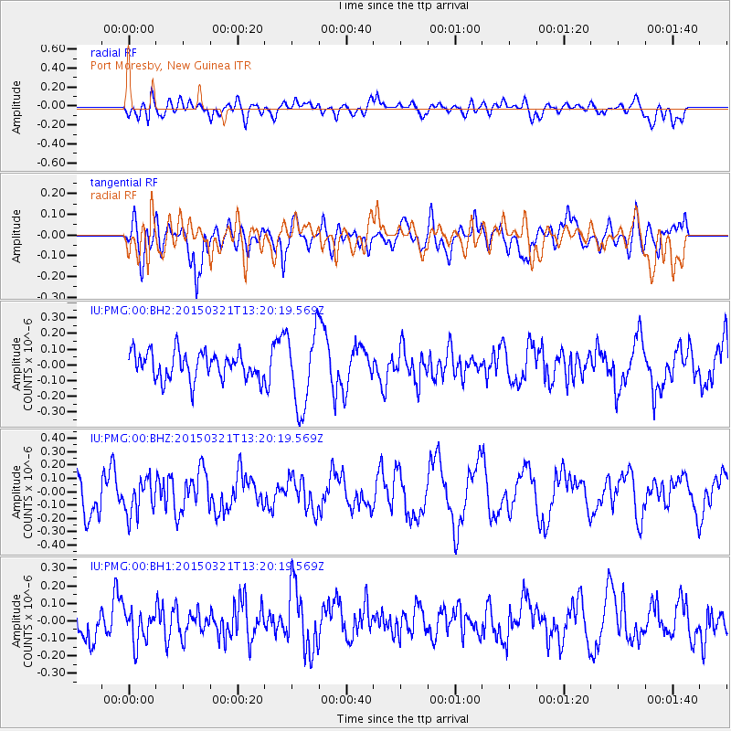
PMG Port Moresby, New Guinea - Earthquake Result Viewer
*The percent match for this event was below the threshold and hence no stack was calculated.
| Earthquake location: |
Kermadec Islands Region |
| Earthquake latitude/longitude: |
-31.7/-178.2 |
| Earthquake time(UTC): |
2015/03/21 (080) 13:13:26 GMT |
| Earthquake Depth: |
35 km |
| Earthquake Magnitude: |
5.1 MW, 4.3 MS, 5.2 mb |
| Earthquake Catalog/Contributor: |
ISC/ISC |
|
| Network: |
IU Global Seismograph Network (GSN - IRIS/USGS) |
| Station: |
PMG Port Moresby, New Guinea |
| Lat/Lon: |
9.40 S/147.16 E |
| Elevation: |
90 m |
|
| Distance: |
39.0 deg |
| Az: |
297.051 deg |
| Baz: |
129.713 deg |
| Ray Param: |
$rayparam |
*The percent match for this event was below the threshold and hence was not used in the summary stack. |
|
| Radial Match: |
46.885563 % |
| Radial Bump: |
400 |
| Transverse Match: |
65.1915 % |
| Transverse Bump: |
400 |
| SOD ConfigId: |
7422571 |
| Insert Time: |
2019-04-17 20:38:46.523 +0000 |
| GWidth: |
2.5 |
| Max Bumps: |
400 |
| Tol: |
0.001 |
|
Signal To Noise
| Channel | StoN | STA | LTA |
| IU:PMG:00:BHZ:20150321T13:20:19.569Z | 0.84976065 | 1.346139E-7 | 1.584139E-7 |
| IU:PMG:00:BH1:20150321T13:20:19.569Z | 0.8746817 | 9.1314035E-8 | 1.04396875E-7 |
| IU:PMG:00:BH2:20150321T13:20:19.569Z | 2.7718294 | 2.410039E-7 | 8.69476E-8 |
| Arrivals |
| Ps | |
| PpPs | |
| PsPs/PpSs | |


