You are here: Home > Network List > TA - USArray Transportable Network (new EarthScope stations) Stations List
> Station V62A Hyde County Airport, Englehard, NC, USA > Earthquake Result Viewer
V62A Hyde County Airport, Englehard, NC, USA - Earthquake Result Viewer

| Earthquake location: |
Rat Islands, Aleutian Islands |
| Earthquake latitude/longitude: |
51.8/178.8 |
| Earthquake time(UTC): |
2014/06/23 (174) 20:53:09 GMT |
| Earthquake Depth: |
108 km |
| Earthquake Magnitude: |
7.9 MWW, 7.1 MI, 7.9 MWC |
| Earthquake Catalog/Contributor: |
NEIC PDE/NEIC COMCAT |
|
| Network: |
TA USArray Transportable Network (new EarthScope stations) |
| Station: |
V62A Hyde County Airport, Englehard, NC, USA |
| Lat/Lon: |
35.56 N/75.96 W |
| Elevation: |
-3.0 m |
|
| Distance: |
71.3 deg |
| Az: |
56.125 deg |
| Baz: |
320.774 deg |
| Ray Param: |
0.054139555 |
| Estimated Moho Depth: |
13.5 km |
| Estimated Crust Vp/Vs: |
1.92 |
| Assumed Crust Vp: |
5.738 km/s |
| Estimated Crust Vs: |
2.993 km/s |
| Estimated Crust Poisson's Ratio: |
0.31 |
|
| Radial Match: |
95.48832 % |
| Radial Bump: |
324 |
| Transverse Match: |
81.85815 % |
| Transverse Bump: |
400 |
| SOD ConfigId: |
739768 |
| Insert Time: |
2014-07-07 22:00:54.252 +0000 |
| GWidth: |
2.5 |
| Max Bumps: |
400 |
| Tol: |
0.001 |
|
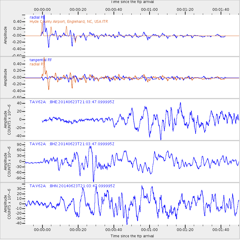
Signal To Noise
| Channel | StoN | STA | LTA |
| TA:V62A: :BHZ:20140623T21:03:47.099995Z | 2.923797 | 8.813713E-6 | 3.0144752E-6 |
| TA:V62A: :BHN:20140623T21:03:47.099995Z | 1.2439649 | 3.146743E-6 | 2.5296074E-6 |
| TA:V62A: :BHE:20140623T21:03:47.099995Z | 0.8516046 | 2.9328614E-6 | 3.4439238E-6 |
| Arrivals |
| Ps | 2.2 SECOND |
| PpPs | 6.7 SECOND |
| PsPs/PpSs | 8.9 SECOND |


