You are here: Home > Network List > TA - USArray Transportable Network (new EarthScope stations) Stations List
> Station W41B Gary Mavity, Velonia, AR, USA > Earthquake Result Viewer
W41B Gary Mavity, Velonia, AR, USA - Earthquake Result Viewer
| Earthquake location: |
Rat Islands, Aleutian Islands |
| Earthquake latitude/longitude: |
51.8/178.8 |
| Earthquake time(UTC): |
2014/06/23 (174) 20:53:09 GMT |
| Earthquake Depth: |
108 km |
| Earthquake Magnitude: |
7.9 MWW, 7.1 MI, 7.9 MWC |
| Earthquake Catalog/Contributor: |
NEIC PDE/NEIC COMCAT |
|
| Network: |
TA USArray Transportable Network (new EarthScope stations) |
| Station: |
W41B Gary Mavity, Velonia, AR, USA |
| Lat/Lon: |
35.17 N/92.25 W |
| Elevation: |
95 m |
|
| Distance: |
62.7 deg |
| Az: |
67.169 deg |
| Baz: |
315.681 deg |
| Ray Param: |
0.05974984 |
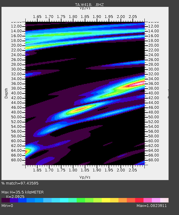
| Estimated Moho Depth: |
35.5 km |
| Estimated Crust Vp/Vs: |
2.09 |
| Assumed Crust Vp: |
6.498 km/s |
| Estimated Crust Vs: |
3.105 km/s |
| Estimated Crust Poisson's Ratio: |
0.35 |
|
| Radial Match: |
97.43595 % |
| Radial Bump: |
297 |
| Transverse Match: |
59.275345 % |
| Transverse Bump: |
398 |
| SOD ConfigId: |
739768 |
| Insert Time: |
2014-07-07 22:01:02.720 +0000 |
| GWidth: |
2.5 |
| Max Bumps: |
400 |
| Tol: |
0.001 |
|

Signal To Noise
| Channel | StoN | STA | LTA |
| TA:W41B: :BHZ:20140623T21:02:52.800007Z | 2.5327613 | 1.2654528E-5 | 4.996337E-6 |
| TA:W41B: :BHN:20140623T21:02:52.800007Z | 1.2850581 | 7.016016E-6 | 5.4596876E-6 |
| TA:W41B: :BHE:20140623T21:02:52.800007Z | 1.1859951 | 4.046318E-6 | 3.4117493E-6 |
| Arrivals |
| Ps | 6.2 SECOND |
| PpPs | 16 SECOND |
| PsPs/PpSs | 22 SECOND |


