You are here: Home > Network List > TA - USArray Transportable Network (new EarthScope stations) Stations List
> Station W57A Gilead, NC, USA > Earthquake Result Viewer
W57A Gilead, NC, USA - Earthquake Result Viewer
| Earthquake location: |
Rat Islands, Aleutian Islands |
| Earthquake latitude/longitude: |
51.8/178.8 |
| Earthquake time(UTC): |
2014/06/23 (174) 20:53:09 GMT |
| Earthquake Depth: |
108 km |
| Earthquake Magnitude: |
7.9 MWW, 7.1 MI, 7.9 MWC |
| Earthquake Catalog/Contributor: |
NEIC PDE/NEIC COMCAT |
|
| Network: |
TA USArray Transportable Network (new EarthScope stations) |
| Station: |
W57A Gilead, NC, USA |
| Lat/Lon: |
35.15 N/79.99 W |
| Elevation: |
85 m |
|
| Distance: |
69.5 deg |
| Az: |
59.089 deg |
| Baz: |
319.442 deg |
| Ray Param: |
0.055321388 |
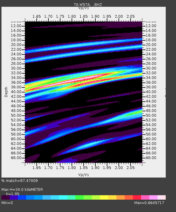
| Estimated Moho Depth: |
34.0 km |
| Estimated Crust Vp/Vs: |
1.85 |
| Assumed Crust Vp: |
6.565 km/s |
| Estimated Crust Vs: |
3.548 km/s |
| Estimated Crust Poisson's Ratio: |
0.29 |
|
| Radial Match: |
97.47809 % |
| Radial Bump: |
329 |
| Transverse Match: |
78.68806 % |
| Transverse Bump: |
400 |
| SOD ConfigId: |
739768 |
| Insert Time: |
2014-07-07 22:01:10.740 +0000 |
| GWidth: |
2.5 |
| Max Bumps: |
400 |
| Tol: |
0.001 |
|
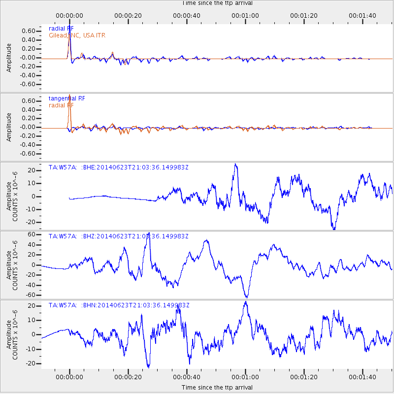
Signal To Noise
| Channel | StoN | STA | LTA |
| TA:W57A: :BHZ:20140623T21:03:36.149983Z | 2.3746784 | 4.5124575E-6 | 1.9002395E-6 |
| TA:W57A: :BHN:20140623T21:03:36.149983Z | 1.1871842 | 2.3227383E-6 | 1.9565102E-6 |
| TA:W57A: :BHE:20140623T21:03:36.149983Z | 2.1520588 | 1.7773674E-6 | 8.258917E-7 |
| Arrivals |
| Ps | 4.6 SECOND |
| PpPs | 14 SECOND |
| PsPs/PpSs | 19 SECOND |


