You are here: Home > Network List > II - Global Seismograph Network (GSN - IRIS/IDA) Stations List
> Station WRAB Tennant Creek, NT, Australia > Earthquake Result Viewer
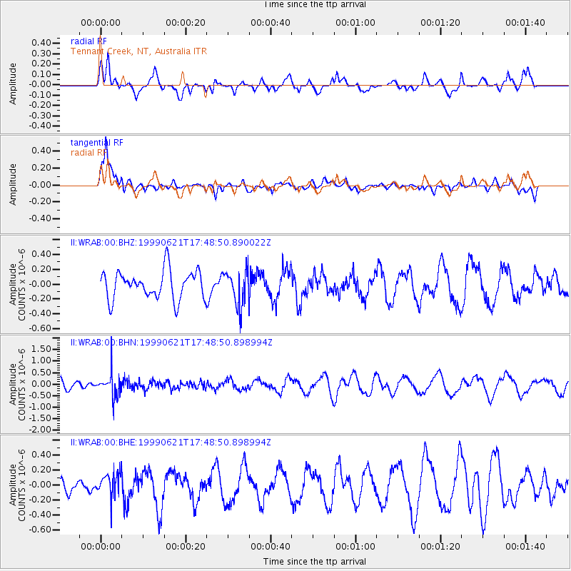
WRAB Tennant Creek, NT, Australia - Earthquake Result Viewer
*The percent match for this event was below the threshold and hence no stack was calculated.
| Earthquake location: |
Hindu Kush Region, Afghanistan |
| Earthquake latitude/longitude: |
36.4/70.7 |
| Earthquake time(UTC): |
1999/06/21 (172) 17:37:27 GMT |
| Earthquake Depth: |
230 km |
| Earthquake Magnitude: |
5.6 MW, 5.4 MB, 5.5 MW |
| Earthquake Catalog/Contributor: |
WHDF/NEIC |
|
| Network: |
II Global Seismograph Network (GSN - IRIS/IDA) |
| Station: |
WRAB Tennant Creek, NT, Australia |
| Lat/Lon: |
19.93 S/134.36 E |
| Elevation: |
366 m |
|
| Distance: |
82.1 deg |
| Az: |
121.67 deg |
| Baz: |
313.118 deg |
| Ray Param: |
$rayparam |
*The percent match for this event was below the threshold and hence was not used in the summary stack. |
|
| Radial Match: |
47.738575 % |
| Radial Bump: |
400 |
| Transverse Match: |
80.841805 % |
| Transverse Bump: |
400 |
| SOD ConfigId: |
4480 |
| Insert Time: |
2010-03-01 23:25:59.777 +0000 |
| GWidth: |
2.5 |
| Max Bumps: |
400 |
| Tol: |
0.001 |
|
Signal To Noise
| Channel | StoN | STA | LTA |
| II:WRAB:00:BHN:19990621T17:48:50.898994Z | 2.487691 | 5.143733E-7 | 2.0676737E-7 |
| II:WRAB:00:BHE:19990621T17:48:50.898994Z | 1.1365311 | 1.5665856E-7 | 1.3783922E-7 |
| II:WRAB:00:BHZ:19990621T17:48:50.890022Z | 1.2739497 | 2.4352298E-7 | 1.9115586E-7 |
| Arrivals |
| Ps | |
| PpPs | |
| PsPs/PpSs | |


