You are here: Home > Network List > US - United States National Seismic Network Stations List
> Station MSO Missoula, Montana, USA > Earthquake Result Viewer
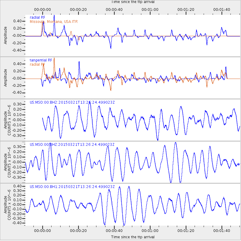
MSO Missoula, Montana, USA - Earthquake Result Viewer
*The percent match for this event was below the threshold and hence no stack was calculated.
| Earthquake location: |
Kermadec Islands Region |
| Earthquake latitude/longitude: |
-31.7/-178.2 |
| Earthquake time(UTC): |
2015/03/21 (080) 13:13:26 GMT |
| Earthquake Depth: |
35 km |
| Earthquake Magnitude: |
5.1 MW, 4.3 MS, 5.2 mb |
| Earthquake Catalog/Contributor: |
ISC/ISC |
|
| Network: |
US United States National Seismic Network |
| Station: |
MSO Missoula, Montana, USA |
| Lat/Lon: |
46.83 N/113.94 W |
| Elevation: |
1264 m |
|
| Distance: |
97.3 deg |
| Az: |
38.574 deg |
| Baz: |
230.712 deg |
| Ray Param: |
$rayparam |
*The percent match for this event was below the threshold and hence was not used in the summary stack. |
|
| Radial Match: |
48.936794 % |
| Radial Bump: |
371 |
| Transverse Match: |
53.393093 % |
| Transverse Bump: |
367 |
| SOD ConfigId: |
7422571 |
| Insert Time: |
2019-04-17 20:40:10.752 +0000 |
| GWidth: |
2.5 |
| Max Bumps: |
400 |
| Tol: |
0.001 |
|
Signal To Noise
| Channel | StoN | STA | LTA |
| US:MSO:00:BHZ:20150321T13:26:24.499023Z | 3.071616 | 2.3957185E-7 | 7.799539E-8 |
| US:MSO:00:BH1:20150321T13:26:24.499023Z | 0.9391353 | 9.571047E-8 | 1.0191339E-7 |
| US:MSO:00:BH2:20150321T13:26:24.499023Z | 1.2101221 | 1.8706807E-7 | 1.545861E-7 |
| Arrivals |
| Ps | |
| PpPs | |
| PsPs/PpSs | |


