You are here: Home > Network List > II - Global Seismograph Network (GSN - IRIS/IDA) Stations List
> Station WRAB Tennant Creek, NT, Australia > Earthquake Result Viewer
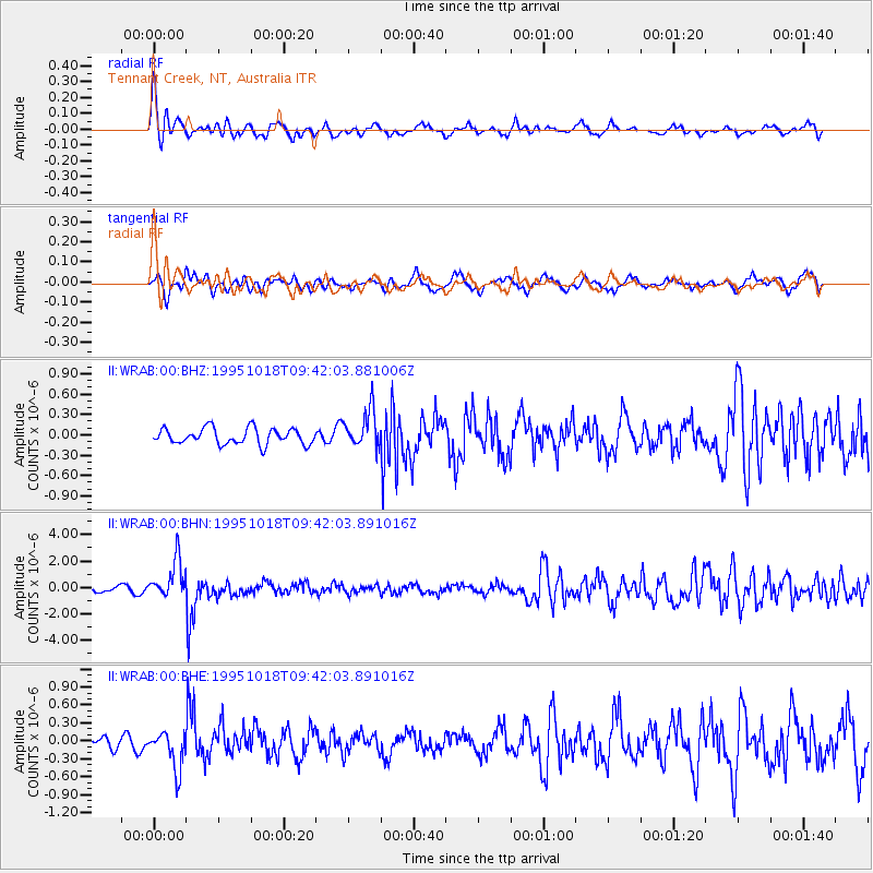
WRAB Tennant Creek, NT, Australia - Earthquake Result Viewer
*The percent match for this event was below the threshold and hence no stack was calculated.
| Earthquake location: |
Hindu Kush Region, Afghanistan |
| Earthquake latitude/longitude: |
36.4/70.4 |
| Earthquake time(UTC): |
1995/10/18 (291) 09:30:38 GMT |
| Earthquake Depth: |
226 km |
| Earthquake Magnitude: |
5.4 MB, 6.2 UNKNOWN, 6.2 MW |
| Earthquake Catalog/Contributor: |
WHDF/NEIC |
|
| Network: |
II Global Seismograph Network (GSN - IRIS/IDA) |
| Station: |
WRAB Tennant Creek, NT, Australia |
| Lat/Lon: |
19.93 S/134.36 E |
| Elevation: |
366 m |
|
| Distance: |
82.4 deg |
| Az: |
121.496 deg |
| Baz: |
313.044 deg |
| Ray Param: |
$rayparam |
*The percent match for this event was below the threshold and hence was not used in the summary stack. |
|
| Radial Match: |
75.20016 % |
| Radial Bump: |
400 |
| Transverse Match: |
65.2258 % |
| Transverse Bump: |
400 |
| SOD ConfigId: |
4480 |
| Insert Time: |
2010-03-01 23:26:16.351 +0000 |
| GWidth: |
2.5 |
| Max Bumps: |
400 |
| Tol: |
0.001 |
|
Signal To Noise
| Channel | StoN | STA | LTA |
| II:WRAB:00:BHN:19951018T09:42:03.891016Z | 4.069647 | 1.4237858E-6 | 3.4985484E-7 |
| II:WRAB:00:BHE:19951018T09:42:03.891016Z | 1.5696598 | 3.1686886E-7 | 2.0187103E-7 |
| II:WRAB:00:BHZ:19951018T09:42:03.881006Z | 2.3340585 | 2.7325845E-7 | 1.17074386E-7 |
| Arrivals |
| Ps | |
| PpPs | |
| PsPs/PpSs | |


