You are here: Home > Network List > UU - University of Utah Regional Network Stations List
> Station PKCU Pink Cliffs, UT, USA > Earthquake Result Viewer
PKCU Pink Cliffs, UT, USA - Earthquake Result Viewer
| Earthquake location: |
Rat Islands, Aleutian Islands |
| Earthquake latitude/longitude: |
51.8/178.8 |
| Earthquake time(UTC): |
2014/06/23 (174) 20:53:09 GMT |
| Earthquake Depth: |
108 km |
| Earthquake Magnitude: |
7.9 MWW, 7.1 MI, 7.9 MWC |
| Earthquake Catalog/Contributor: |
NEIC PDE/NEIC COMCAT |
|
| Network: |
UU University of Utah Regional Network |
| Station: |
PKCU Pink Cliffs, UT, USA |
| Lat/Lon: |
37.44 N/112.31 W |
| Elevation: |
2834 m |
|
| Distance: |
49.3 deg |
| Az: |
78.458 deg |
| Baz: |
310.14 deg |
| Ray Param: |
0.06844539 |
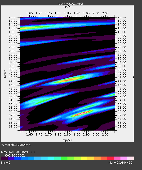
| Estimated Moho Depth: |
61.0 km |
| Estimated Crust Vp/Vs: |
1.92 |
| Assumed Crust Vp: |
6.194 km/s |
| Estimated Crust Vs: |
3.226 km/s |
| Estimated Crust Poisson's Ratio: |
0.31 |
|
| Radial Match: |
83.92955 % |
| Radial Bump: |
344 |
| Transverse Match: |
69.868774 % |
| Transverse Bump: |
379 |
| SOD ConfigId: |
739768 |
| Insert Time: |
2014-07-07 22:07:44.321 +0000 |
| GWidth: |
2.5 |
| Max Bumps: |
400 |
| Tol: |
0.001 |
|

Signal To Noise
| Channel | StoN | STA | LTA |
| UU:PKCU:01:HHZ:20140623T21:01:17.420002Z | 3.2889173 | 2.5053154E-7 | 7.617447E-8 |
| UU:PKCU:01:HHN:20140623T21:01:17.420002Z | 0.7447079 | 5.5851324E-8 | 7.499763E-8 |
| UU:PKCU:01:HHE:20140623T21:01:17.420002Z | 2.2157974 | 1.9911474E-7 | 8.986143E-8 |
| Arrivals |
| Ps | 9.5 SECOND |
| PpPs | 27 SECOND |
| PsPs/PpSs | 37 SECOND |


