You are here: Home > Network List > UW - Pacific Northwest Regional Seismic Network Stations List
> Station LTY Liberty (broad-band) > Earthquake Result Viewer
LTY Liberty (broad-band) - Earthquake Result Viewer
| Earthquake location: |
Rat Islands, Aleutian Islands |
| Earthquake latitude/longitude: |
51.8/178.8 |
| Earthquake time(UTC): |
2014/06/23 (174) 20:53:09 GMT |
| Earthquake Depth: |
108 km |
| Earthquake Magnitude: |
7.9 MWW, 7.1 MI, 7.9 MWC |
| Earthquake Catalog/Contributor: |
NEIC PDE/NEIC COMCAT |
|
| Network: |
UW Pacific Northwest Regional Seismic Network |
| Station: |
LTY Liberty (broad-band) |
| Lat/Lon: |
47.26 N/120.66 W |
| Elevation: |
970 m |
|
| Distance: |
38.6 deg |
| Az: |
72.038 deg |
| Baz: |
299.861 deg |
| Ray Param: |
0.075112246 |
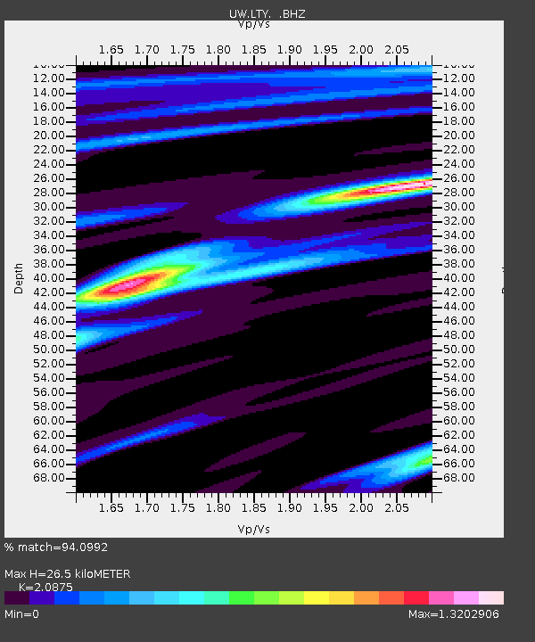
| Estimated Moho Depth: |
26.5 km |
| Estimated Crust Vp/Vs: |
2.09 |
| Assumed Crust Vp: |
6.597 km/s |
| Estimated Crust Vs: |
3.16 km/s |
| Estimated Crust Poisson's Ratio: |
0.35 |
|
| Radial Match: |
94.0992 % |
| Radial Bump: |
380 |
| Transverse Match: |
91.01755 % |
| Transverse Bump: |
347 |
| SOD ConfigId: |
739768 |
| Insert Time: |
2014-07-07 22:09:35.513 +0000 |
| GWidth: |
2.5 |
| Max Bumps: |
400 |
| Tol: |
0.001 |
|

Signal To Noise
| Channel | StoN | STA | LTA |
| UW:LTY: :BHZ:20140623T20:59:52.105Z | 2.186776 | 6.016718E-6 | 2.7514102E-6 |
| UW:LTY: :BHN:20140623T20:59:52.105Z | 3.4176235 | 2.1089165E-6 | 6.1707107E-7 |
| UW:LTY: :BHE:20140623T20:59:52.105Z | 1.5649239 | 3.738799E-6 | 2.3891253E-6 |
| Arrivals |
| Ps | 4.7 SECOND |
| PpPs | 12 SECOND |
| PsPs/PpSs | 16 SECOND |


