You are here: Home > Network List > UW - Pacific Northwest Regional Seismic Network Stations List
> Station OMAK Colville Reservation, Omak, WA, USA > Earthquake Result Viewer
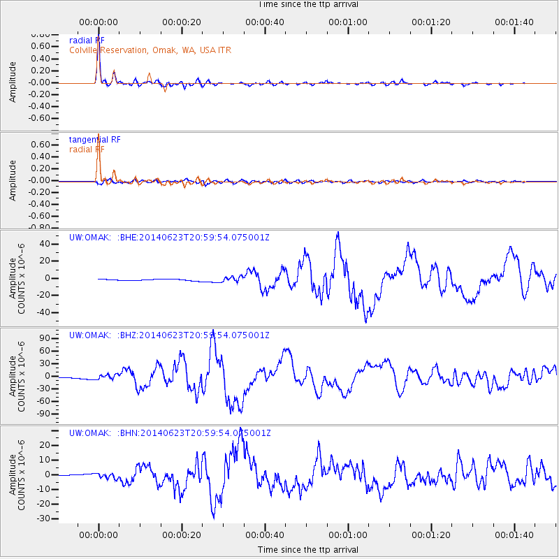
OMAK Colville Reservation, Omak, WA, USA - Earthquake Result Viewer

| Earthquake location: |
Rat Islands, Aleutian Islands |
| Earthquake latitude/longitude: |
51.8/178.8 |
| Earthquake time(UTC): |
2014/06/23 (174) 20:53:09 GMT |
| Earthquake Depth: |
108 km |
| Earthquake Magnitude: |
7.9 MWW, 7.1 MI, 7.9 MWC |
| Earthquake Catalog/Contributor: |
NEIC PDE/NEIC COMCAT |
|
| Network: |
UW Pacific Northwest Regional Seismic Network |
| Station: |
OMAK Colville Reservation, Omak, WA, USA |
| Lat/Lon: |
48.36 N/119.33 W |
| Elevation: |
696 m |
|
| Distance: |
38.8 deg |
| Az: |
69.795 deg |
| Baz: |
299.095 deg |
| Ray Param: |
0.07497544 |
| Estimated Moho Depth: |
37.25 km |
| Estimated Crust Vp/Vs: |
1.61 |
| Assumed Crust Vp: |
6.419 km/s |
| Estimated Crust Vs: |
4.0 km/s |
| Estimated Crust Poisson's Ratio: |
0.18 |
|
| Radial Match: |
98.19521 % |
| Radial Bump: |
286 |
| Transverse Match: |
89.679886 % |
| Transverse Bump: |
400 |
| SOD ConfigId: |
739768 |
| Insert Time: |
2014-07-07 22:09:55.755 +0000 |
| GWidth: |
2.5 |
| Max Bumps: |
400 |
| Tol: |
0.001 |
|
Signal To Noise
| Channel | StoN | STA | LTA |
| UW:OMAK: :BHZ:20140623T20:59:54.075001Z | 3.675913 | 5.6161207E-6 | 1.5278165E-6 |
| UW:OMAK: :BHN:20140623T20:59:54.075001Z | 2.2642636 | 1.7299228E-6 | 7.640112E-7 |
| UW:OMAK: :BHE:20140623T20:59:54.075001Z | 3.5367262 | 3.0072576E-6 | 8.502941E-7 |
| Arrivals |
| Ps | 3.8 SECOND |
| PpPs | 14 SECOND |
| PsPs/PpSs | 18 SECOND |


