You are here: Home > Network List > TA - USArray Transportable Network (new EarthScope stations) Stations List
> Station D04E Lakebay, WA, USA > Earthquake Result Viewer
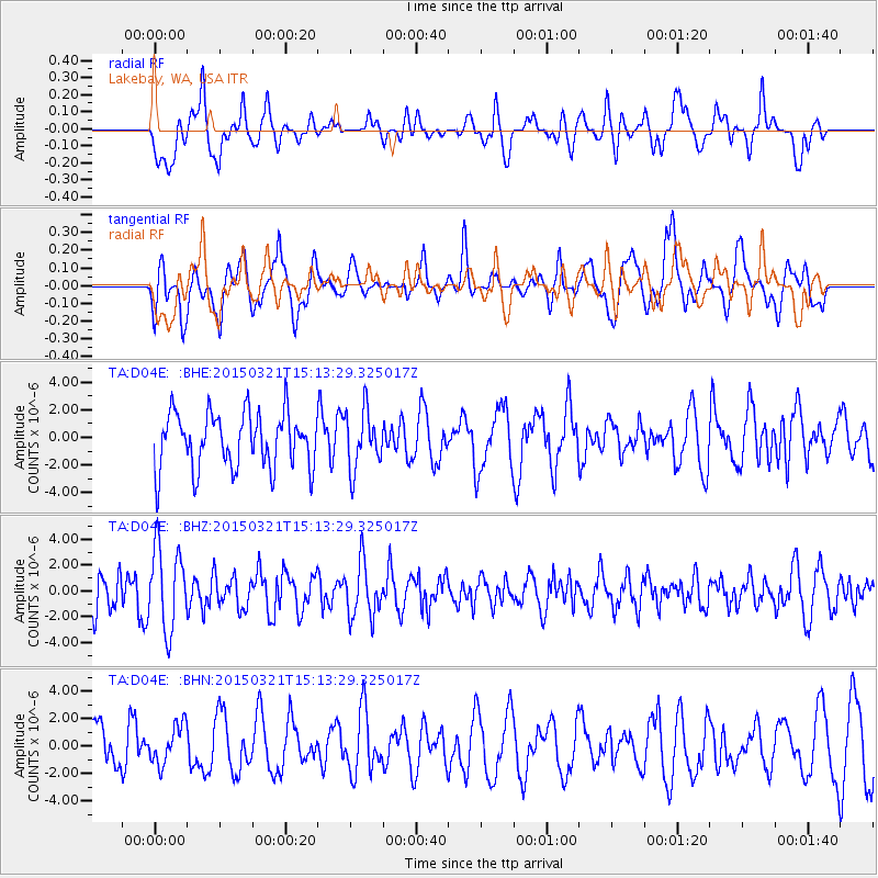
D04E Lakebay, WA, USA - Earthquake Result Viewer
*The percent match for this event was below the threshold and hence no stack was calculated.
| Earthquake location: |
Mariana Islands |
| Earthquake latitude/longitude: |
13.1/145.8 |
| Earthquake time(UTC): |
2015/03/21 (080) 15:01:43 GMT |
| Earthquake Depth: |
10 km |
| Earthquake Magnitude: |
4.7 mb, 3.8 MS, 4.6 mb |
| Earthquake Catalog/Contributor: |
ISC/ISC |
|
| Network: |
TA USArray Transportable Network (new EarthScope stations) |
| Station: |
D04E Lakebay, WA, USA |
| Lat/Lon: |
47.18 N/122.77 W |
| Elevation: |
45 m |
|
| Distance: |
81.5 deg |
| Az: |
43.594 deg |
| Baz: |
280.014 deg |
| Ray Param: |
$rayparam |
*The percent match for this event was below the threshold and hence was not used in the summary stack. |
|
| Radial Match: |
41.615887 % |
| Radial Bump: |
400 |
| Transverse Match: |
59.519047 % |
| Transverse Bump: |
400 |
| SOD ConfigId: |
7422571 |
| Insert Time: |
2019-04-17 20:44:19.322 +0000 |
| GWidth: |
2.5 |
| Max Bumps: |
400 |
| Tol: |
0.001 |
|
Signal To Noise
| Channel | StoN | STA | LTA |
| TA:D04E: :BHZ:20150321T15:13:29.325017Z | 1.4754299 | 3.193839E-6 | 2.1646836E-6 |
| TA:D04E: :BHN:20150321T15:13:29.325017Z | 0.967454 | 1.4270413E-6 | 1.4750482E-6 |
| TA:D04E: :BHE:20150321T15:13:29.325017Z | 1.0419976 | 2.086152E-6 | 2.00207E-6 |
| Arrivals |
| Ps | |
| PpPs | |
| PsPs/PpSs | |


