You are here: Home > Network List > II - Global Seismograph Network (GSN - IRIS/IDA) Stations List
> Station WRAB Tennant Creek, NT, Australia > Earthquake Result Viewer
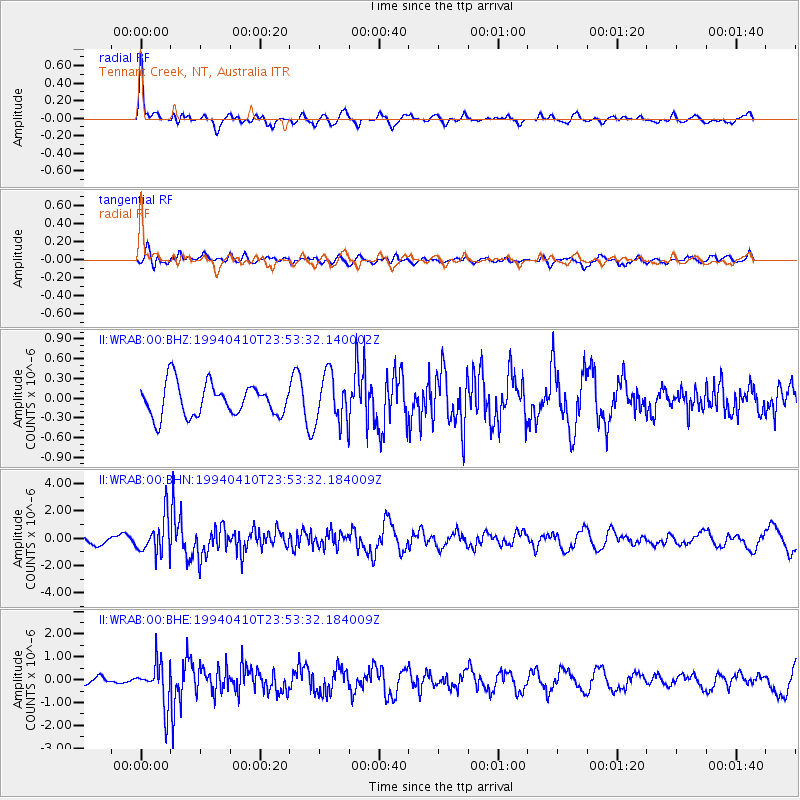
WRAB Tennant Creek, NT, Australia - Earthquake Result Viewer
*The percent match for this event was below the threshold and hence no stack was calculated.
| Earthquake location: |
Southeast Of Ryukyu Islands |
| Earthquake latitude/longitude: |
23.7/126.8 |
| Earthquake time(UTC): |
1994/04/10 (100) 23:45:55 GMT |
| Earthquake Depth: |
10 km |
| Earthquake Magnitude: |
5.9 MB, 5.8 MS, 6.1 UNKNOWN, 6.1 MW |
| Earthquake Catalog/Contributor: |
WHDF/NEIC |
|
| Network: |
II Global Seismograph Network (GSN - IRIS/IDA) |
| Station: |
WRAB Tennant Creek, NT, Australia |
| Lat/Lon: |
19.93 S/134.36 E |
| Elevation: |
366 m |
|
| Distance: |
44.0 deg |
| Az: |
169.797 deg |
| Baz: |
350.062 deg |
| Ray Param: |
$rayparam |
*The percent match for this event was below the threshold and hence was not used in the summary stack. |
|
| Radial Match: |
72.28863 % |
| Radial Bump: |
400 |
| Transverse Match: |
56.424904 % |
| Transverse Bump: |
400 |
| SOD ConfigId: |
4480 |
| Insert Time: |
2010-03-01 23:26:33.401 +0000 |
| GWidth: |
2.5 |
| Max Bumps: |
400 |
| Tol: |
0.001 |
|
Signal To Noise
| Channel | StoN | STA | LTA |
| II:WRAB:00:BHN:19940410T23:53:32.184009Z | 4.3825645 | 1.3548977E-6 | 3.0915638E-7 |
| II:WRAB:00:BHE:19940410T23:53:32.184009Z | 4.9700117 | 9.173769E-7 | 1.8458243E-7 |
| II:WRAB:00:BHZ:19940410T23:53:32.140002Z | 1.5365075 | 3.7280338E-7 | 2.4263036E-7 |
| Arrivals |
| Ps | |
| PpPs | |
| PsPs/PpSs | |


