You are here: Home > Network List > TA - USArray Transportable Network (new EarthScope stations) Stations List
> Station R11A Troy Canyon, Currant, NV, USA > Earthquake Result Viewer
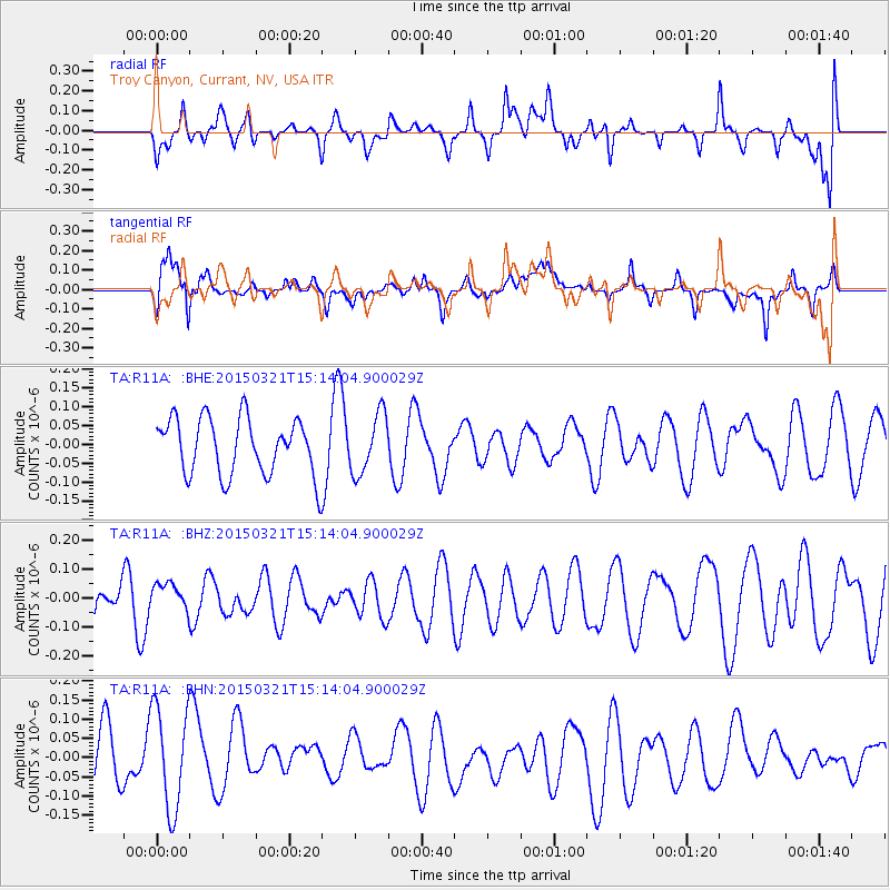
R11A Troy Canyon, Currant, NV, USA - Earthquake Result Viewer
*The percent match for this event was below the threshold and hence no stack was calculated.
| Earthquake location: |
Mariana Islands |
| Earthquake latitude/longitude: |
13.1/145.8 |
| Earthquake time(UTC): |
2015/03/21 (080) 15:01:43 GMT |
| Earthquake Depth: |
10 km |
| Earthquake Magnitude: |
4.7 mb, 3.8 MS, 4.6 mb |
| Earthquake Catalog/Contributor: |
ISC/ISC |
|
| Network: |
TA USArray Transportable Network (new EarthScope stations) |
| Station: |
R11A Troy Canyon, Currant, NV, USA |
| Lat/Lon: |
38.35 N/115.59 W |
| Elevation: |
1756 m |
|
| Distance: |
88.6 deg |
| Az: |
51.039 deg |
| Baz: |
285.538 deg |
| Ray Param: |
$rayparam |
*The percent match for this event was below the threshold and hence was not used in the summary stack. |
|
| Radial Match: |
51.97632 % |
| Radial Bump: |
400 |
| Transverse Match: |
66.67404 % |
| Transverse Bump: |
400 |
| SOD ConfigId: |
7422571 |
| Insert Time: |
2019-04-17 20:44:26.661 +0000 |
| GWidth: |
2.5 |
| Max Bumps: |
400 |
| Tol: |
0.001 |
|
Signal To Noise
| Channel | StoN | STA | LTA |
| TA:R11A: :BHZ:20150321T15:14:04.900029Z | 0.5176284 | 4.759761E-8 | 9.195325E-8 |
| TA:R11A: :BHN:20150321T15:14:04.900029Z | 1.740892 | 1.3767557E-7 | 7.908334E-8 |
| TA:R11A: :BHE:20150321T15:14:04.900029Z | 1.0525002 | 7.8376495E-8 | 7.446696E-8 |
| Arrivals |
| Ps | |
| PpPs | |
| PsPs/PpSs | |


