You are here: Home > Network List > UW - Pacific Northwest Regional Seismic Network Stations List
> Station PASS Maple Falls, WA, USA > Earthquake Result Viewer
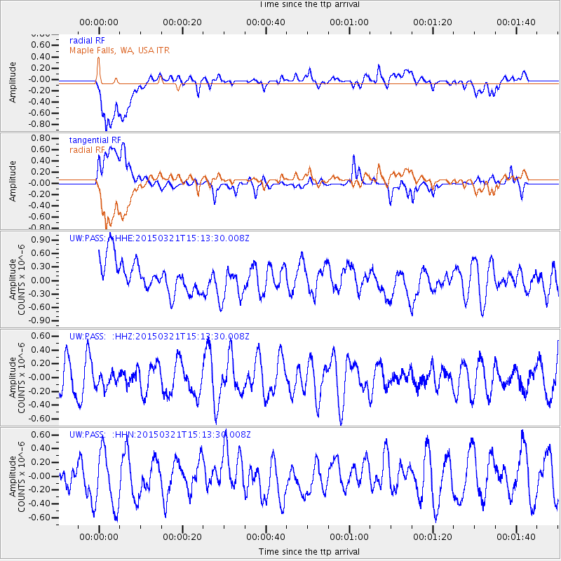
PASS Maple Falls, WA, USA - Earthquake Result Viewer
*The percent match for this event was below the threshold and hence no stack was calculated.
| Earthquake location: |
Mariana Islands |
| Earthquake latitude/longitude: |
13.1/145.8 |
| Earthquake time(UTC): |
2015/03/21 (080) 15:01:43 GMT |
| Earthquake Depth: |
10 km |
| Earthquake Magnitude: |
4.7 mb, 3.8 MS, 4.6 mb |
| Earthquake Catalog/Contributor: |
ISC/ISC |
|
| Network: |
UW Pacific Northwest Regional Seismic Network |
| Station: |
PASS Maple Falls, WA, USA |
| Lat/Lon: |
49.00 N/122.09 W |
| Elevation: |
174 m |
|
| Distance: |
81.6 deg |
| Az: |
41.7 deg |
| Baz: |
280.245 deg |
| Ray Param: |
$rayparam |
*The percent match for this event was below the threshold and hence was not used in the summary stack. |
|
| Radial Match: |
56.158245 % |
| Radial Bump: |
400 |
| Transverse Match: |
47.126324 % |
| Transverse Bump: |
400 |
| SOD ConfigId: |
7422571 |
| Insert Time: |
2019-04-17 20:45:05.175 +0000 |
| GWidth: |
2.5 |
| Max Bumps: |
400 |
| Tol: |
0.001 |
|
Signal To Noise
| Channel | StoN | STA | LTA |
| UW:PASS: :HHZ:20150321T15:13:30.008Z | 0.5454836 | 1.0094714E-7 | 1.850599E-7 |
| UW:PASS: :HHN:20150321T15:13:30.008Z | 2.289745 | 4.3468162E-7 | 1.8983843E-7 |
| UW:PASS: :HHE:20150321T15:13:30.008Z | 1.1331766 | 3.9717267E-7 | 3.5049496E-7 |
| Arrivals |
| Ps | |
| PpPs | |
| PsPs/PpSs | |


