You are here: Home > Network List > WY - Yellowstone Wyoming Seismic Network Stations List
> Station YHH Holmes Hill, YNP, WY, USA > Earthquake Result Viewer
YHH Holmes Hill, YNP, WY, USA - Earthquake Result Viewer
| Earthquake location: |
Rat Islands, Aleutian Islands |
| Earthquake latitude/longitude: |
51.8/178.8 |
| Earthquake time(UTC): |
2014/06/23 (174) 20:53:09 GMT |
| Earthquake Depth: |
108 km |
| Earthquake Magnitude: |
7.9 MWW, 7.1 MI, 7.9 MWC |
| Earthquake Catalog/Contributor: |
NEIC PDE/NEIC COMCAT |
|
| Network: |
WY Yellowstone Wyoming Seismic Network |
| Station: |
YHH Holmes Hill, YNP, WY, USA |
| Lat/Lon: |
44.79 N/110.85 W |
| Elevation: |
2717 m |
|
| Distance: |
45.7 deg |
| Az: |
69.658 deg |
| Baz: |
305.143 deg |
| Ray Param: |
0.07076043 |
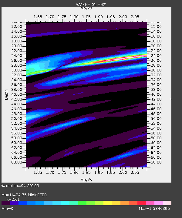
| Estimated Moho Depth: |
24.75 km |
| Estimated Crust Vp/Vs: |
2.01 |
| Assumed Crust Vp: |
6.35 km/s |
| Estimated Crust Vs: |
3.159 km/s |
| Estimated Crust Poisson's Ratio: |
0.34 |
|
| Radial Match: |
94.39199 % |
| Radial Bump: |
363 |
| Transverse Match: |
80.909935 % |
| Transverse Bump: |
400 |
| SOD ConfigId: |
739768 |
| Insert Time: |
2014-07-07 22:12:37.460 +0000 |
| GWidth: |
2.5 |
| Max Bumps: |
400 |
| Tol: |
0.001 |
|

Signal To Noise
| Channel | StoN | STA | LTA |
| WY:YHH:01:HHZ:20140623T21:00:49.498005Z | 1.9826399 | 2.105746E-7 | 1.062092E-7 |
| WY:YHH:01:HHN:20140623T21:00:49.498005Z | 1.3696024 | 8.814072E-8 | 6.435497E-8 |
| WY:YHH:01:HHE:20140623T21:00:49.498005Z | 1.8066568 | 1.4435193E-7 | 7.9900026E-8 |
| Arrivals |
| Ps | 4.2 SECOND |
| PpPs | 11 SECOND |
| PsPs/PpSs | 15 SECOND |


