You are here: Home > Network List > II - Global Seismograph Network (GSN - IRIS/IDA) Stations List
> Station WRAB Tennant Creek, NT, Australia > Earthquake Result Viewer
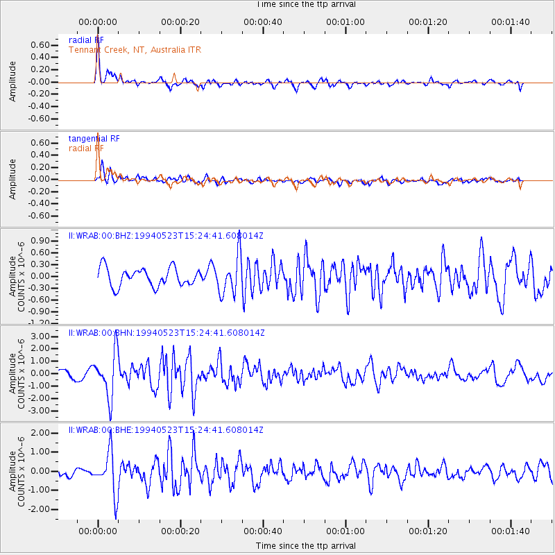
WRAB Tennant Creek, NT, Australia - Earthquake Result Viewer
*The percent match for this event was below the threshold and hence no stack was calculated.
| Earthquake location: |
Taiwan Region |
| Earthquake latitude/longitude: |
24.0/122.6 |
| Earthquake time(UTC): |
1994/05/23 (143) 15:16:58 GMT |
| Earthquake Depth: |
33 km |
| Earthquake Magnitude: |
5.9 MB, 5.7 MS, 6.0 UNKNOWN, 5.9 MW |
| Earthquake Catalog/Contributor: |
WHDF/NEIC |
|
| Network: |
II Global Seismograph Network (GSN - IRIS/IDA) |
| Station: |
WRAB Tennant Creek, NT, Australia |
| Lat/Lon: |
19.93 S/134.36 E |
| Elevation: |
366 m |
|
| Distance: |
45.2 deg |
| Az: |
164.275 deg |
| Baz: |
344.73 deg |
| Ray Param: |
$rayparam |
*The percent match for this event was below the threshold and hence was not used in the summary stack. |
|
| Radial Match: |
75.18678 % |
| Radial Bump: |
400 |
| Transverse Match: |
72.40689 % |
| Transverse Bump: |
400 |
| SOD ConfigId: |
4480 |
| Insert Time: |
2010-03-01 23:26:44.179 +0000 |
| GWidth: |
2.5 |
| Max Bumps: |
400 |
| Tol: |
0.001 |
|
Signal To Noise
| Channel | StoN | STA | LTA |
| II:WRAB:00:BHN:19940523T15:24:41.608014Z | 3.7054079 | 1.8661938E-6 | 5.036406E-7 |
| II:WRAB:00:BHE:19940523T15:24:41.608014Z | 4.5428987 | 1.1320387E-6 | 2.4918862E-7 |
| II:WRAB:00:BHZ:19940523T15:24:41.608014Z | 2.194216 | 5.0813037E-7 | 2.315772E-7 |
| Arrivals |
| Ps | |
| PpPs | |
| PsPs/PpSs | |


