You are here: Home > Network List > II - Global Seismograph Network (GSN - IRIS/IDA) Stations List
> Station WRAB Tennant Creek, NT, Australia > Earthquake Result Viewer
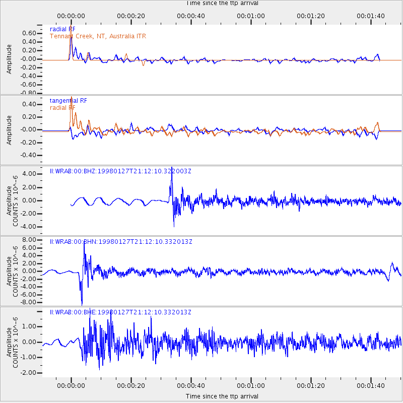
WRAB Tennant Creek, NT, Australia - Earthquake Result Viewer
*The percent match for this event was below the threshold and hence no stack was calculated.
| Earthquake location: |
South Of Fiji Islands |
| Earthquake latitude/longitude: |
-22.4/179.0 |
| Earthquake time(UTC): |
1998/01/27 (027) 21:05:44 GMT |
| Earthquake Depth: |
610 km |
| Earthquake Magnitude: |
5.6 MB, 6.5 UNKNOWN, 6.4 MW |
| Earthquake Catalog/Contributor: |
WHDF/NEIC |
|
| Network: |
II Global Seismograph Network (GSN - IRIS/IDA) |
| Station: |
WRAB Tennant Creek, NT, Australia |
| Lat/Lon: |
19.93 S/134.36 E |
| Elevation: |
366 m |
|
| Distance: |
41.6 deg |
| Az: |
264.816 deg |
| Baz: |
101.605 deg |
| Ray Param: |
$rayparam |
*The percent match for this event was below the threshold and hence was not used in the summary stack. |
|
| Radial Match: |
77.64947 % |
| Radial Bump: |
380 |
| Transverse Match: |
63.00006 % |
| Transverse Bump: |
400 |
| SOD ConfigId: |
4480 |
| Insert Time: |
2010-03-01 23:26:47.687 +0000 |
| GWidth: |
2.5 |
| Max Bumps: |
400 |
| Tol: |
0.001 |
|
Signal To Noise
| Channel | StoN | STA | LTA |
| II:WRAB:00:BHN:19980127T21:12:10.332013Z | 4.3821177 | 2.7512742E-6 | 6.2784125E-7 |
| II:WRAB:00:BHE:19980127T21:12:10.332013Z | 1.8703066 | 3.849537E-7 | 2.0582385E-7 |
| II:WRAB:00:BHZ:19980127T21:12:10.322003Z | 3.5796216 | 1.4061354E-6 | 3.928168E-7 |
| Arrivals |
| Ps | |
| PpPs | |
| PsPs/PpSs | |


