You are here: Home > Network List > YN10 - San Jacinto Fault Zone Stations List
> Station JFS2 JFS2 > Earthquake Result Viewer
JFS2 JFS2 - Earthquake Result Viewer
| Earthquake location: |
Rat Islands, Aleutian Islands |
| Earthquake latitude/longitude: |
51.8/178.8 |
| Earthquake time(UTC): |
2014/06/23 (174) 20:53:09 GMT |
| Earthquake Depth: |
108 km |
| Earthquake Magnitude: |
7.9 MWW, 7.1 MI, 7.9 MWC |
| Earthquake Catalog/Contributor: |
NEIC PDE/NEIC COMCAT |
|
| Network: |
YN San Jacinto Fault Zone |
| Station: |
JFS2 JFS2 |
| Lat/Lon: |
33.42 N/116.40 W |
| Elevation: |
645 m |
|
| Distance: |
49.4 deg |
| Az: |
85.337 deg |
| Baz: |
312.261 deg |
| Ray Param: |
0.06836515 |
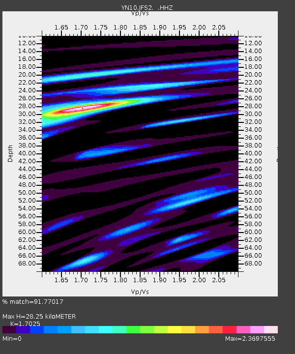
| Estimated Moho Depth: |
28.25 km |
| Estimated Crust Vp/Vs: |
1.70 |
| Assumed Crust Vp: |
6.264 km/s |
| Estimated Crust Vs: |
3.679 km/s |
| Estimated Crust Poisson's Ratio: |
0.24 |
|
| Radial Match: |
91.77017 % |
| Radial Bump: |
400 |
| Transverse Match: |
87.29632 % |
| Transverse Bump: |
400 |
| SOD ConfigId: |
739768 |
| Insert Time: |
2014-07-07 22:14:01.184 +0000 |
| GWidth: |
2.5 |
| Max Bumps: |
400 |
| Tol: |
0.001 |
|

Signal To Noise
| Channel | StoN | STA | LTA |
| YN:JFS2: :HHZ:20140623T21:01:18.383992Z | 6.7790327 | 1.4711581E-5 | 2.1701594E-6 |
| YN:JFS2: :HHN:20140623T21:01:18.383992Z | 5.634959 | 4.5840884E-6 | 8.1350873E-7 |
| YN:JFS2: :HHE:20140623T21:01:18.383992Z | 11.799096 | 7.513868E-6 | 6.368172E-7 |
| Arrivals |
| Ps | 3.4 SECOND |
| PpPs | 12 SECOND |
| PsPs/PpSs | 15 SECOND |


