You are here: Home > Network List > PY - PFO Array Stations List
> Station BPH07 Pinon Flat Observatory, CA, USA > Earthquake Result Viewer
BPH07 Pinon Flat Observatory, CA, USA - Earthquake Result Viewer
| Earthquake location: |
Rat Islands, Aleutian Islands |
| Earthquake latitude/longitude: |
51.8/178.8 |
| Earthquake time(UTC): |
2014/06/23 (174) 20:53:09 GMT |
| Earthquake Depth: |
108 km |
| Earthquake Magnitude: |
7.9 MWW, 7.1 MI, 7.9 MWC |
| Earthquake Catalog/Contributor: |
NEIC PDE/NEIC COMCAT |
|
| Network: |
PY PFO Array |
| Station: |
BPH07 Pinon Flat Observatory, CA, USA |
| Lat/Lon: |
33.61 N/116.46 W |
| Elevation: |
1275 m |
|
| Distance: |
49.3 deg |
| Az: |
85.196 deg |
| Baz: |
312.14 deg |
| Ray Param: |
0.06846396 |
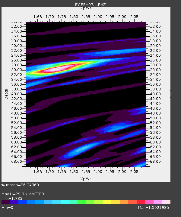
| Estimated Moho Depth: |
29.0 km |
| Estimated Crust Vp/Vs: |
1.74 |
| Assumed Crust Vp: |
6.264 km/s |
| Estimated Crust Vs: |
3.61 km/s |
| Estimated Crust Poisson's Ratio: |
0.25 |
|
| Radial Match: |
96.34368 % |
| Radial Bump: |
305 |
| Transverse Match: |
81.81829 % |
| Transverse Bump: |
400 |
| SOD ConfigId: |
739768 |
| Insert Time: |
2014-07-07 22:15:11.562 +0000 |
| GWidth: |
2.5 |
| Max Bumps: |
400 |
| Tol: |
0.001 |
|

Signal To Noise
| Channel | StoN | STA | LTA |
| PY:BPH07: :BHZ:20140623T21:01:17.200001Z | 7.4798493 | 7.999009E-6 | 1.0694077E-6 |
| PY:BPH07: :BHN:20140623T21:01:17.200001Z | 5.432781 | 3.7528291E-6 | 6.907749E-7 |
| PY:BPH07: :BHE:20140623T21:01:17.200001Z | 4.970357 | 3.0574543E-6 | 6.1513776E-7 |
| Arrivals |
| Ps | 3.6 SECOND |
| PpPs | 12 SECOND |
| PsPs/PpSs | 16 SECOND |


