You are here: Home > Network List > II - Global Seismograph Network (GSN - IRIS/IDA) Stations List
> Station WRAB Tennant Creek, NT, Australia > Earthquake Result Viewer
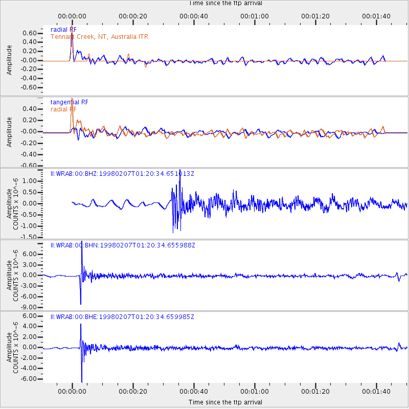
WRAB Tennant Creek, NT, Australia - Earthquake Result Viewer
*The percent match for this event was below the threshold and hence no stack was calculated.
| Earthquake location: |
Volcano Islands, Japan Region |
| Earthquake latitude/longitude: |
24.8/141.8 |
| Earthquake time(UTC): |
1998/02/07 (038) 01:13:36 GMT |
| Earthquake Depth: |
526 km |
| Earthquake Magnitude: |
5.9 UNKNOWN, 5.4 MB |
| Earthquake Catalog/Contributor: |
WHDF/NEIC |
|
| Network: |
II Global Seismograph Network (GSN - IRIS/IDA) |
| Station: |
WRAB Tennant Creek, NT, Australia |
| Lat/Lon: |
19.93 S/134.36 E |
| Elevation: |
366 m |
|
| Distance: |
45.0 deg |
| Az: |
189.851 deg |
| Baz: |
9.514 deg |
| Ray Param: |
$rayparam |
*The percent match for this event was below the threshold and hence was not used in the summary stack. |
|
| Radial Match: |
68.91531 % |
| Radial Bump: |
400 |
| Transverse Match: |
53.775864 % |
| Transverse Bump: |
400 |
| SOD ConfigId: |
4480 |
| Insert Time: |
2010-03-01 23:27:01.246 +0000 |
| GWidth: |
2.5 |
| Max Bumps: |
400 |
| Tol: |
0.001 |
|
Signal To Noise
| Channel | StoN | STA | LTA |
| II:WRAB:00:BHN:19980207T01:20:34.655988Z | 14.727492 | 2.2722234E-6 | 1.5428446E-7 |
| II:WRAB:00:BHE:19980207T01:20:34.659985Z | 13.400166 | 1.50667E-6 | 1.12436666E-7 |
| II:WRAB:00:BHZ:19980207T01:20:34.651013Z | 4.101018 | 4.0149334E-7 | 9.7900895E-8 |
| Arrivals |
| Ps | |
| PpPs | |
| PsPs/PpSs | |


