You are here: Home > Network List > II - Global Seismograph Network (GSN - IRIS/IDA) Stations List
> Station WRAB Tennant Creek, NT, Australia > Earthquake Result Viewer
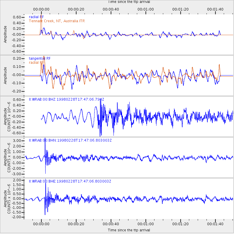
WRAB Tennant Creek, NT, Australia - Earthquake Result Viewer
*The percent match for this event was below the threshold and hence no stack was calculated.
| Earthquake location: |
Southeast Of Honshu, Japan |
| Earthquake latitude/longitude: |
33.5/138.1 |
| Earthquake time(UTC): |
1998/02/28 (059) 17:38:48 GMT |
| Earthquake Depth: |
291 km |
| Earthquake Magnitude: |
5.7 UNKNOWN, 5.3 MB, 5.7 MW |
| Earthquake Catalog/Contributor: |
WHDF/NEIC |
|
| Network: |
II Global Seismograph Network (GSN - IRIS/IDA) |
| Station: |
WRAB Tennant Creek, NT, Australia |
| Lat/Lon: |
19.93 S/134.36 E |
| Elevation: |
366 m |
|
| Distance: |
53.2 deg |
| Az: |
184.423 deg |
| Baz: |
3.929 deg |
| Ray Param: |
$rayparam |
*The percent match for this event was below the threshold and hence was not used in the summary stack. |
|
| Radial Match: |
60.708847 % |
| Radial Bump: |
400 |
| Transverse Match: |
51.56448 % |
| Transverse Bump: |
400 |
| SOD ConfigId: |
4480 |
| Insert Time: |
2010-03-01 23:27:07.305 +0000 |
| GWidth: |
2.5 |
| Max Bumps: |
400 |
| Tol: |
0.001 |
|
Signal To Noise
| Channel | StoN | STA | LTA |
| II:WRAB:00:BHN:19980228T17:47:06.803003Z | 6.3182526 | 9.358663E-7 | 1.4812106E-7 |
| II:WRAB:00:BHE:19980228T17:47:06.803003Z | 5.4447675 | 5.8453406E-7 | 1.0735703E-7 |
| II:WRAB:00:BHZ:19980228T17:47:06.794Z | 2.6561544 | 3.2018337E-7 | 1.2054396E-7 |
| Arrivals |
| Ps | |
| PpPs | |
| PsPs/PpSs | |


