You are here: Home > Network List > N4 - Central and EAstern US Network Stations List
> Station G40A Rib Lake, WI, USA > Earthquake Result Viewer
G40A Rib Lake, WI, USA - Earthquake Result Viewer
| Earthquake location: |
Rat Islands, Aleutian Islands |
| Earthquake latitude/longitude: |
52.0/178.4 |
| Earthquake time(UTC): |
2014/06/23 (174) 21:11:41 GMT |
| Earthquake Depth: |
107 km |
| Earthquake Magnitude: |
6.0 MB |
| Earthquake Catalog/Contributor: |
NEIC PDE/NEIC COMCAT |
|
| Network: |
N4 Central and EAstern US Network |
| Station: |
G40A Rib Lake, WI, USA |
| Lat/Lon: |
45.27 N/90.20 W |
| Elevation: |
472 m |
|
| Distance: |
56.9 deg |
| Az: |
57.399 deg |
| Baz: |
312.43 deg |
| Ray Param: |
0.06350187 |
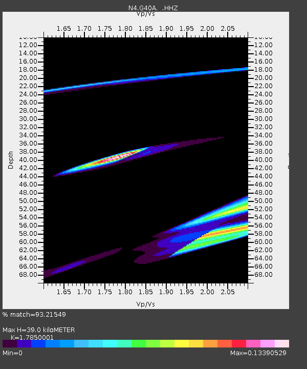
| Estimated Moho Depth: |
39.0 km |
| Estimated Crust Vp/Vs: |
1.79 |
| Assumed Crust Vp: |
6.571 km/s |
| Estimated Crust Vs: |
3.681 km/s |
| Estimated Crust Poisson's Ratio: |
0.27 |
|
| Radial Match: |
93.21549 % |
| Radial Bump: |
400 |
| Transverse Match: |
40.920128 % |
| Transverse Bump: |
400 |
| SOD ConfigId: |
739768 |
| Insert Time: |
2014-07-07 22:30:44.497 +0000 |
| GWidth: |
2.5 |
| Max Bumps: |
400 |
| Tol: |
0.001 |
|

Signal To Noise
| Channel | StoN | STA | LTA |
| N4:G40A: :HHZ:20140623T21:20:44.490015Z | 3.0577965 | 1.3405869E-4 | 4.3841603E-5 |
| N4:G40A: :HHN:20140623T21:20:44.490015Z | 0.16853242 | 8.760752E-6 | 5.198259E-5 |
| N4:G40A: :HHE:20140623T21:20:44.490015Z | 0.5999581 | 2.421223E-5 | 4.0356532E-5 |
| Arrivals |
| Ps | 4.9 SECOND |
| PpPs | 16 SECOND |
| PsPs/PpSs | 21 SECOND |


