You are here: Home > Network List > TA - USArray Transportable Network (new EarthScope stations) Stations List
> Station G59A Clarenceville, QC, USA > Earthquake Result Viewer
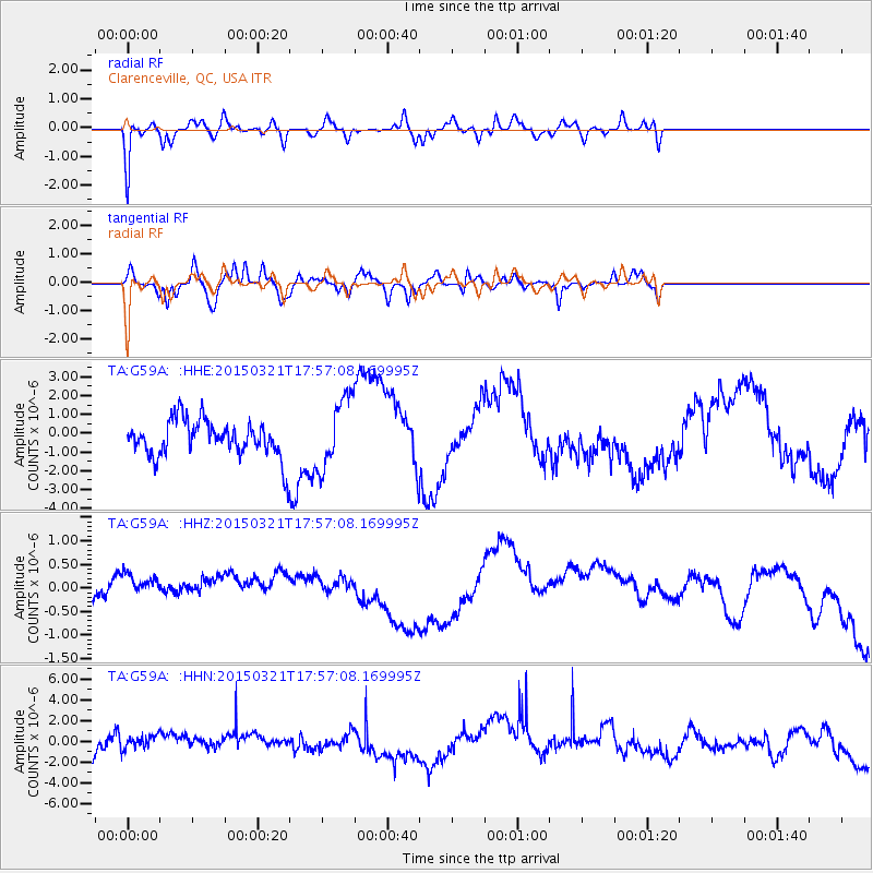
G59A Clarenceville, QC, USA - Earthquake Result Viewer
*The percent match for this event was below the threshold and hence no stack was calculated.
| Earthquake location: |
Afghanistan-Tajikistan Bord Reg. |
| Earthquake latitude/longitude: |
36.4/71.6 |
| Earthquake time(UTC): |
2015/03/21 (080) 17:44:37 GMT |
| Earthquake Depth: |
99 km |
| Earthquake Magnitude: |
4.9 MW, 4.8 mb |
| Earthquake Catalog/Contributor: |
ISC/ISC |
|
| Network: |
TA USArray Transportable Network (new EarthScope stations) |
| Station: |
G59A Clarenceville, QC, USA |
| Lat/Lon: |
45.08 N/73.18 W |
| Elevation: |
36 m |
|
| Distance: |
92.9 deg |
| Az: |
335.863 deg |
| Baz: |
27.745 deg |
| Ray Param: |
$rayparam |
*The percent match for this event was below the threshold and hence was not used in the summary stack. |
|
| Radial Match: |
74.19887 % |
| Radial Bump: |
400 |
| Transverse Match: |
60.17581 % |
| Transverse Bump: |
400 |
| SOD ConfigId: |
7422571 |
| Insert Time: |
2019-04-17 20:49:03.159 +0000 |
| GWidth: |
2.5 |
| Max Bumps: |
400 |
| Tol: |
0.001 |
|
Signal To Noise
| Channel | StoN | STA | LTA |
| TA:G59A: :HHZ:20150321T17:57:08.169995Z | 2.0538497 | 5.23653E-7 | 2.549617E-7 |
| TA:G59A: :HHN:20150321T17:57:08.169995Z | 0.85175115 | 1.1879979E-6 | 1.3947712E-6 |
| TA:G59A: :HHE:20150321T17:57:08.169995Z | 1.9615265 | 1.8653456E-6 | 9.509663E-7 |
| Arrivals |
| Ps | |
| PpPs | |
| PsPs/PpSs | |


