You are here: Home > Network List > II - Global Seismograph Network (GSN - IRIS/IDA) Stations List
> Station WRAB Tennant Creek, NT, Australia > Earthquake Result Viewer
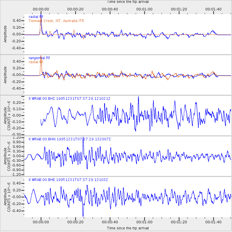
WRAB Tennant Creek, NT, Australia - Earthquake Result Viewer
*The percent match for this event was below the threshold and hence no stack was calculated.
| Earthquake location: |
Near East Coast Of Kamchatka |
| Earthquake latitude/longitude: |
53.9/160.6 |
| Earthquake time(UTC): |
1995/12/31 (365) 07:26:13 GMT |
| Earthquake Depth: |
55 km |
| Earthquake Magnitude: |
6.0 MB, 5.9 UNKNOWN, 5.7 MW |
| Earthquake Catalog/Contributor: |
WHDF/NEIC |
|
| Network: |
II Global Seismograph Network (GSN - IRIS/IDA) |
| Station: |
WRAB Tennant Creek, NT, Australia |
| Lat/Lon: |
19.93 S/134.36 E |
| Elevation: |
366 m |
|
| Distance: |
76.9 deg |
| Az: |
205.295 deg |
| Baz: |
15.599 deg |
| Ray Param: |
$rayparam |
*The percent match for this event was below the threshold and hence was not used in the summary stack. |
|
| Radial Match: |
70.88718 % |
| Radial Bump: |
392 |
| Transverse Match: |
53.905613 % |
| Transverse Bump: |
400 |
| SOD ConfigId: |
4480 |
| Insert Time: |
2010-03-01 23:27:10.805 +0000 |
| GWidth: |
2.5 |
| Max Bumps: |
400 |
| Tol: |
0.001 |
|
Signal To Noise
| Channel | StoN | STA | LTA |
| II:WRAB:00:BHN:19951231T07:37:29.132007Z | 2.3707101 | 2.6585735E-7 | 1.121425E-7 |
| II:WRAB:00:BHE:19951231T07:37:29.13103Z | 0.8640689 | 9.649971E-8 | 1.1168057E-7 |
| II:WRAB:00:BHZ:19951231T07:37:29.121021Z | 1.1042045 | 8.262787E-8 | 7.4830226E-8 |
| Arrivals |
| Ps | |
| PpPs | |
| PsPs/PpSs | |


