You are here: Home > Network List > TA - USArray Transportable Network (new EarthScope stations) Stations List
> Station D51A Lot 18 Range III Mazenod Township, QC, CAN > Earthquake Result Viewer
D51A Lot 18 Range III Mazenod Township, QC, CAN - Earthquake Result Viewer
| Earthquake location: |
Rat Islands, Aleutian Islands |
| Earthquake latitude/longitude: |
52.0/178.4 |
| Earthquake time(UTC): |
2014/06/23 (174) 21:11:41 GMT |
| Earthquake Depth: |
107 km |
| Earthquake Magnitude: |
6.0 MB |
| Earthquake Catalog/Contributor: |
NEIC PDE/NEIC COMCAT |
|
| Network: |
TA USArray Transportable Network (new EarthScope stations) |
| Station: |
D51A Lot 18 Range III Mazenod Township, QC, CAN |
| Lat/Lon: |
47.09 N/79.37 W |
| Elevation: |
282 m |
|
| Distance: |
61.0 deg |
| Az: |
49.752 deg |
| Baz: |
316.282 deg |
| Ray Param: |
0.060829896 |
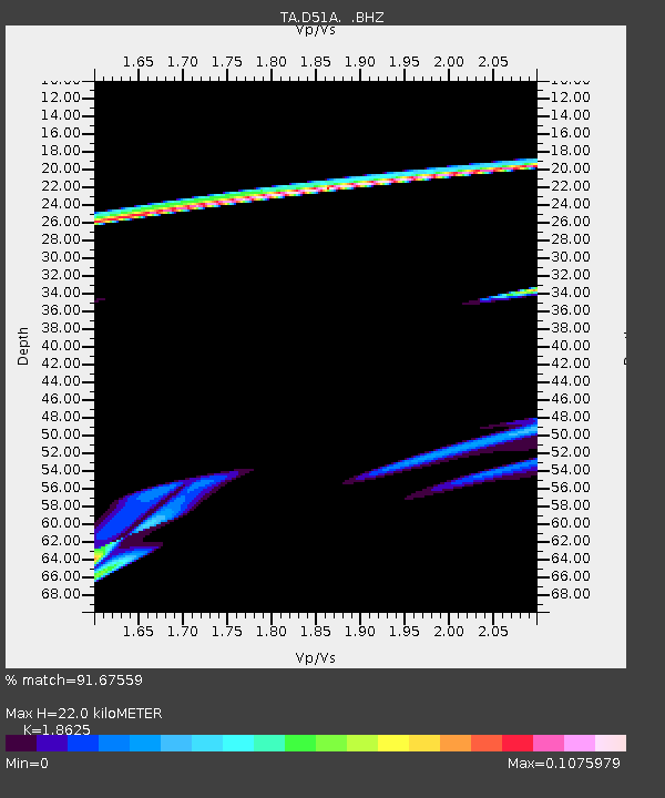
| Estimated Moho Depth: |
22.0 km |
| Estimated Crust Vp/Vs: |
1.86 |
| Assumed Crust Vp: |
6.622 km/s |
| Estimated Crust Vs: |
3.556 km/s |
| Estimated Crust Poisson's Ratio: |
0.30 |
|
| Radial Match: |
91.67559 % |
| Radial Bump: |
351 |
| Transverse Match: |
12.213552 % |
| Transverse Bump: |
188 |
| SOD ConfigId: |
739768 |
| Insert Time: |
2014-07-07 22:40:35.196 +0000 |
| GWidth: |
2.5 |
| Max Bumps: |
400 |
| Tol: |
0.001 |
|
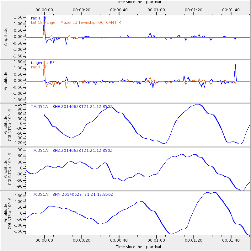
Signal To Noise
| Channel | StoN | STA | LTA |
| TA:D51A: :BHZ:20140623T21:21:12.850Z | 1.7875615 | 2.2158569E-5 | 1.2395975E-5 |
| TA:D51A: :BHN:20140623T21:21:12.850Z | 1.7151637 | 7.518067E-5 | 4.383294E-5 |
| TA:D51A: :BHE:20140623T21:21:12.850Z | 3.0488508 | 1.2217277E-4 | 4.0071747E-5 |
| Arrivals |
| Ps | 3.0 SECOND |
| PpPs | 9.1 SECOND |
| PsPs/PpSs | 12 SECOND |


