You are here: Home > Network List > TA - USArray Transportable Network (new EarthScope stations) Stations List
> Station E47A Iron Bridge, ON, CAN > Earthquake Result Viewer
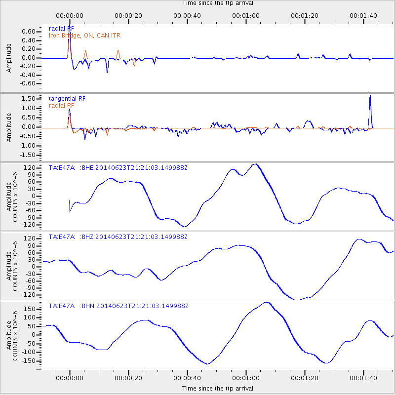
E47A Iron Bridge, ON, CAN - Earthquake Result Viewer
*The percent match for this event was below the threshold and hence no stack was calculated.
| Earthquake location: |
Rat Islands, Aleutian Islands |
| Earthquake latitude/longitude: |
52.0/178.4 |
| Earthquake time(UTC): |
2014/06/23 (174) 21:11:41 GMT |
| Earthquake Depth: |
107 km |
| Earthquake Magnitude: |
6.0 MB |
| Earthquake Catalog/Contributor: |
NEIC PDE/NEIC COMCAT |
|
| Network: |
TA USArray Transportable Network (new EarthScope stations) |
| Station: |
E47A Iron Bridge, ON, CAN |
| Lat/Lon: |
46.45 N/83.28 W |
| Elevation: |
246 m |
|
| Distance: |
59.6 deg |
| Az: |
52.468 deg |
| Baz: |
314.791 deg |
| Ray Param: |
$rayparam |
*The percent match for this event was below the threshold and hence was not used in the summary stack. |
|
| Radial Match: |
94.82395 % |
| Radial Bump: |
255 |
| Transverse Match: |
44.76425 % |
| Transverse Bump: |
345 |
| SOD ConfigId: |
739768 |
| Insert Time: |
2014-07-07 22:40:53.521 +0000 |
| GWidth: |
2.5 |
| Max Bumps: |
400 |
| Tol: |
0.001 |
|
Signal To Noise
| Channel | StoN | STA | LTA |
| TA:E47A: :BHZ:20140623T21:21:03.149988Z | 1.9409895 | 2.2637741E-5 | 1.1662991E-5 |
| TA:E47A: :BHN:20140623T21:21:03.149988Z | 1.1089786 | 5.5270622E-5 | 4.9839215E-5 |
| TA:E47A: :BHE:20140623T21:21:03.149988Z | 2.9099982 | 1.2307552E-4 | 4.2294017E-5 |
| Arrivals |
| Ps | |
| PpPs | |
| PsPs/PpSs | |


