You are here: Home > Network List > II - Global Seismograph Network (GSN - IRIS/IDA) Stations List
> Station WRAB Tennant Creek, NT, Australia > Earthquake Result Viewer
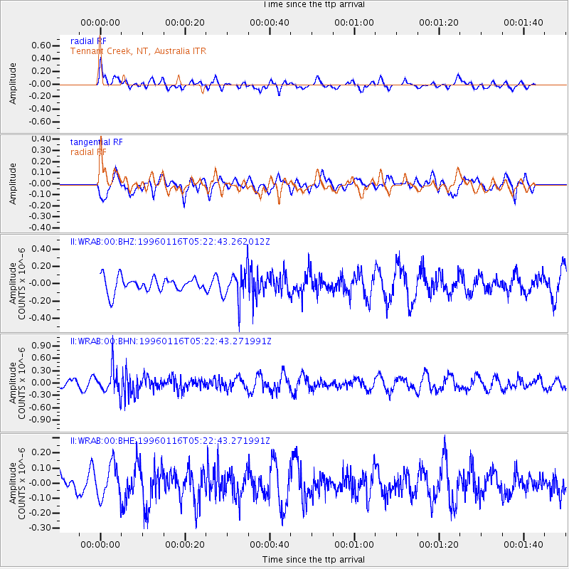
WRAB Tennant Creek, NT, Australia - Earthquake Result Viewer
*The percent match for this event was below the threshold and hence no stack was calculated.
| Earthquake location: |
Fiji Islands Region |
| Earthquake latitude/longitude: |
-18.7/-177.5 |
| Earthquake time(UTC): |
1996/01/16 (016) 05:15:27 GMT |
| Earthquake Depth: |
334 km |
| Earthquake Magnitude: |
5.7 UNKNOWN, 5.4 MB |
| Earthquake Catalog/Contributor: |
WHDF/NEIC |
|
| Network: |
II Global Seismograph Network (GSN - IRIS/IDA) |
| Station: |
WRAB Tennant Creek, NT, Australia |
| Lat/Lon: |
19.93 S/134.36 E |
| Elevation: |
366 m |
|
| Distance: |
45.4 deg |
| Az: |
260.185 deg |
| Baz: |
96.917 deg |
| Ray Param: |
$rayparam |
*The percent match for this event was below the threshold and hence was not used in the summary stack. |
|
| Radial Match: |
63.83795 % |
| Radial Bump: |
400 |
| Transverse Match: |
59.89295 % |
| Transverse Bump: |
400 |
| SOD ConfigId: |
4480 |
| Insert Time: |
2010-03-01 23:27:21.796 +0000 |
| GWidth: |
2.5 |
| Max Bumps: |
400 |
| Tol: |
0.001 |
|
Signal To Noise
| Channel | StoN | STA | LTA |
| II:WRAB:00:BHN:19960116T05:22:43.271991Z | 2.418565 | 3.2164496E-7 | 1.3299E-7 |
| II:WRAB:00:BHE:19960116T05:22:43.271991Z | 1.397818 | 1.15263916E-7 | 8.245989E-8 |
| II:WRAB:00:BHZ:19960116T05:22:43.262012Z | 2.1602461 | 1.8012813E-7 | 8.338315E-8 |
| Arrivals |
| Ps | |
| PpPs | |
| PsPs/PpSs | |


