You are here: Home > Network List > TA - USArray Transportable Network (new EarthScope stations) Stations List
> Station G45A Suttons Bay, MI, USA > Earthquake Result Viewer
G45A Suttons Bay, MI, USA - Earthquake Result Viewer
| Earthquake location: |
Rat Islands, Aleutian Islands |
| Earthquake latitude/longitude: |
52.0/178.4 |
| Earthquake time(UTC): |
2014/06/23 (174) 21:11:41 GMT |
| Earthquake Depth: |
107 km |
| Earthquake Magnitude: |
6.0 MB |
| Earthquake Catalog/Contributor: |
NEIC PDE/NEIC COMCAT |
|
| Network: |
TA USArray Transportable Network (new EarthScope stations) |
| Station: |
G45A Suttons Bay, MI, USA |
| Lat/Lon: |
45.04 N/85.66 W |
| Elevation: |
284 m |
|
| Distance: |
59.4 deg |
| Az: |
54.994 deg |
| Baz: |
314.373 deg |
| Ray Param: |
0.061887674 |
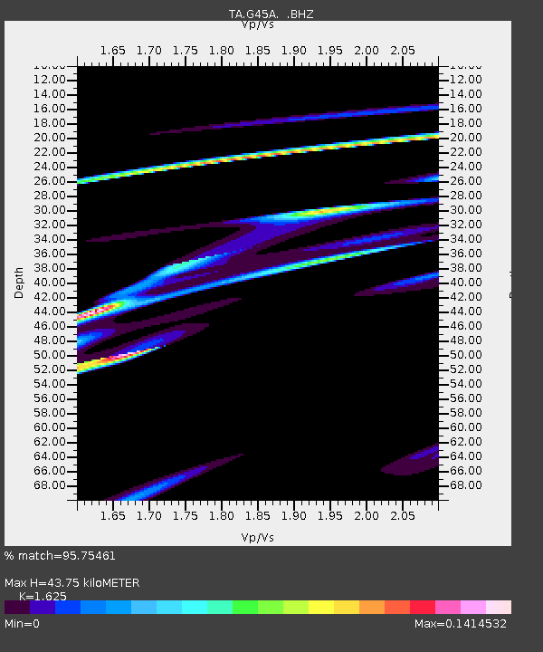
| Estimated Moho Depth: |
43.75 km |
| Estimated Crust Vp/Vs: |
1.62 |
| Assumed Crust Vp: |
6.483 km/s |
| Estimated Crust Vs: |
3.989 km/s |
| Estimated Crust Poisson's Ratio: |
0.20 |
|
| Radial Match: |
95.75461 % |
| Radial Bump: |
341 |
| Transverse Match: |
31.279167 % |
| Transverse Bump: |
400 |
| SOD ConfigId: |
739768 |
| Insert Time: |
2014-07-07 22:41:42.300 +0000 |
| GWidth: |
2.5 |
| Max Bumps: |
400 |
| Tol: |
0.001 |
|

Signal To Noise
| Channel | StoN | STA | LTA |
| TA:G45A: :BHZ:20140623T21:21:01.824976Z | 0.41878915 | 5.1888464E-6 | 1.2390116E-5 |
| TA:G45A: :BHN:20140623T21:21:01.824976Z | 0.57093674 | 2.2158054E-5 | 3.8809998E-5 |
| TA:G45A: :BHE:20140623T21:21:01.824976Z | 2.0849025 | 6.860172E-5 | 3.2904045E-5 |
| Arrivals |
| Ps | 4.4 SECOND |
| PpPs | 17 SECOND |
| PsPs/PpSs | 21 SECOND |


