You are here: Home > Network List > TA - USArray Transportable Network (new EarthScope stations) Stations List
> Station H47A Mio, MI, USA > Earthquake Result Viewer
H47A Mio, MI, USA - Earthquake Result Viewer
| Earthquake location: |
Rat Islands, Aleutian Islands |
| Earthquake latitude/longitude: |
52.0/178.4 |
| Earthquake time(UTC): |
2014/06/23 (174) 21:11:41 GMT |
| Earthquake Depth: |
107 km |
| Earthquake Magnitude: |
6.0 MB |
| Earthquake Catalog/Contributor: |
NEIC PDE/NEIC COMCAT |
|
| Network: |
TA USArray Transportable Network (new EarthScope stations) |
| Station: |
H47A Mio, MI, USA |
| Lat/Lon: |
44.60 N/84.21 W |
| Elevation: |
356 m |
|
| Distance: |
60.5 deg |
| Az: |
54.516 deg |
| Baz: |
315.153 deg |
| Ray Param: |
0.061204907 |
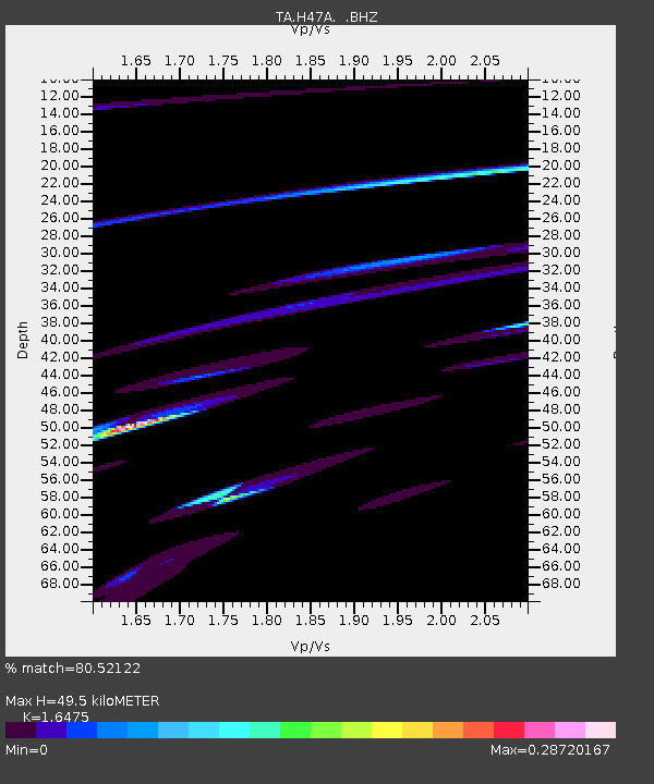
| Estimated Moho Depth: |
49.5 km |
| Estimated Crust Vp/Vs: |
1.65 |
| Assumed Crust Vp: |
6.483 km/s |
| Estimated Crust Vs: |
3.935 km/s |
| Estimated Crust Poisson's Ratio: |
0.21 |
|
| Radial Match: |
80.52122 % |
| Radial Bump: |
271 |
| Transverse Match: |
21.18059 % |
| Transverse Bump: |
155 |
| SOD ConfigId: |
739768 |
| Insert Time: |
2014-07-07 22:42:01.188 +0000 |
| GWidth: |
2.5 |
| Max Bumps: |
400 |
| Tol: |
0.001 |
|

Signal To Noise
| Channel | StoN | STA | LTA |
| TA:H47A: :BHZ:20140623T21:21:08.949976Z | 2.601586 | 3.4334797E-5 | 1.3197639E-5 |
| TA:H47A: :BHN:20140623T21:21:08.949976Z | 3.8967977 | 6.473658E-5 | 1.6612763E-5 |
| TA:H47A: :BHE:20140623T21:21:08.949976Z | 3.2377152 | 7.214666E-5 | 2.22832E-5 |
| Arrivals |
| Ps | 5.2 SECOND |
| PpPs | 19 SECOND |
| PsPs/PpSs | 24 SECOND |


