You are here: Home > Network List > TA - USArray Transportable Network (new EarthScope stations) Stations List
> Station I46A Reed City, MI, USA > Earthquake Result Viewer
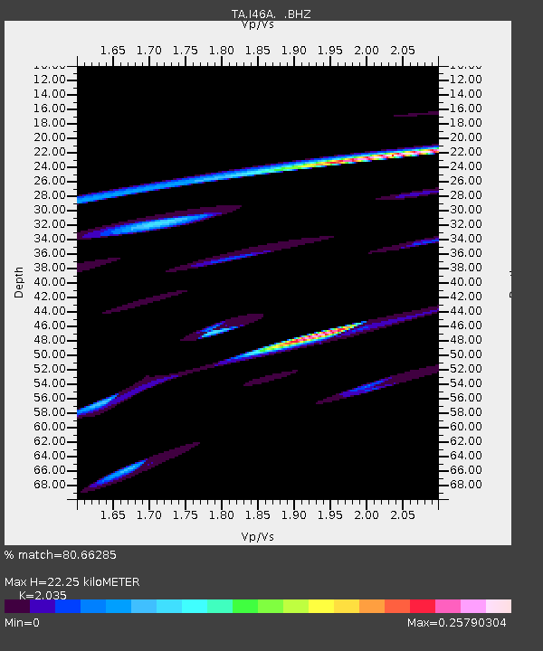
I46A Reed City, MI, USA - Earthquake Result Viewer
| Earthquake location: |
Rat Islands, Aleutian Islands |
| Earthquake latitude/longitude: |
52.0/178.4 |
| Earthquake time(UTC): |
2014/06/23 (174) 21:11:41 GMT |
| Earthquake Depth: |
107 km |
| Earthquake Magnitude: |
6.0 MB |
| Earthquake Catalog/Contributor: |
NEIC PDE/NEIC COMCAT |
|
| Network: |
TA USArray Transportable Network (new EarthScope stations) |
| Station: |
I46A Reed City, MI, USA |
| Lat/Lon: |
43.94 N/85.45 W |
| Elevation: |
359 m |
|
| Distance: |
60.3 deg |
| Az: |
55.777 deg |
| Baz: |
314.913 deg |
| Ray Param: |
0.061312906 |
| Estimated Moho Depth: |
22.25 km |
| Estimated Crust Vp/Vs: |
2.04 |
| Assumed Crust Vp: |
6.483 km/s |
| Estimated Crust Vs: |
3.186 km/s |
| Estimated Crust Poisson's Ratio: |
0.34 |
|
| Radial Match: |
80.66285 % |
| Radial Bump: |
272 |
| Transverse Match: |
26.709892 % |
| Transverse Bump: |
256 |
| SOD ConfigId: |
739768 |
| Insert Time: |
2014-07-07 22:42:32.271 +0000 |
| GWidth: |
2.5 |
| Max Bumps: |
400 |
| Tol: |
0.001 |
|

Signal To Noise
| Channel | StoN | STA | LTA |
| TA:I46A: :BHZ:20140623T21:21:07.824976Z | 1.3021405 | 2.746719E-5 | 2.1093874E-5 |
| TA:I46A: :BHN:20140623T21:21:07.824976Z | 2.3684509 | 6.0272647E-5 | 2.5448131E-5 |
| TA:I46A: :BHE:20140623T21:21:07.824976Z | 2.5980167 | 6.596943E-5 | 2.5392226E-5 |
| Arrivals |
| Ps | 3.7 SECOND |
| PpPs | 10.0 SECOND |
| PsPs/PpSs | 14 SECOND |


