You are here: Home > Network List > II - Global Seismograph Network (GSN - IRIS/IDA) Stations List
> Station WRAB Tennant Creek, NT, Australia > Earthquake Result Viewer
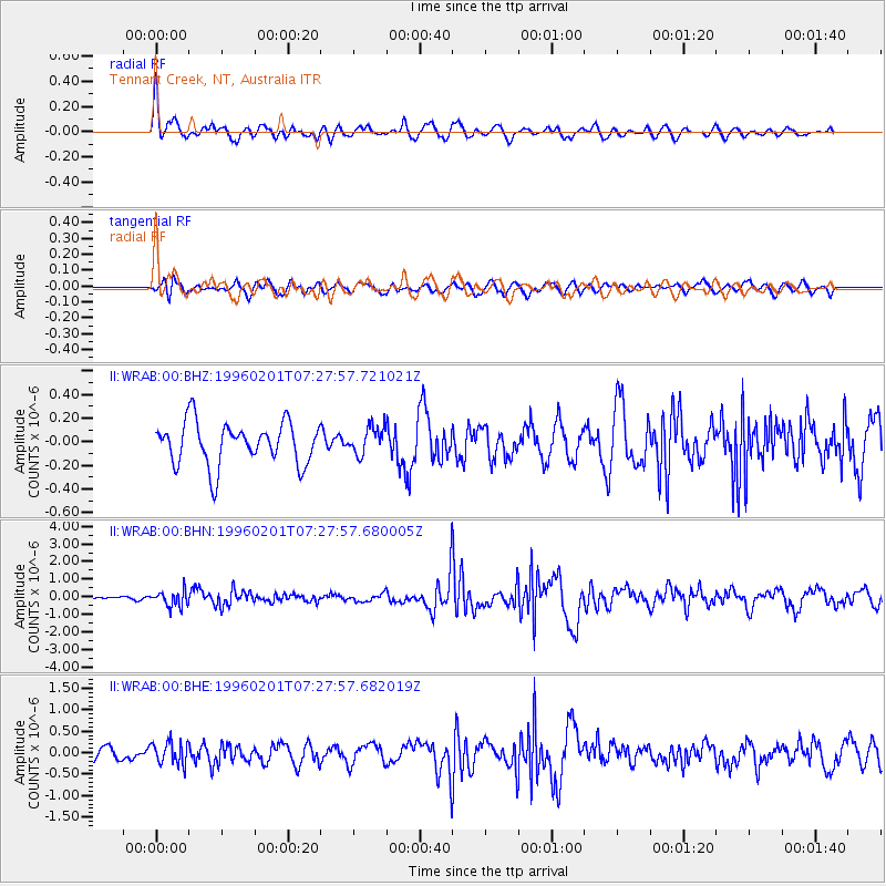
WRAB Tennant Creek, NT, Australia - Earthquake Result Viewer
*The percent match for this event was below the threshold and hence no stack was calculated.
| Earthquake location: |
Kuril Islands |
| Earthquake latitude/longitude: |
44.9/146.3 |
| Earthquake time(UTC): |
1996/02/01 (032) 07:18:05 GMT |
| Earthquake Depth: |
180 km |
| Earthquake Magnitude: |
5.7 MB, 6.2 UNKNOWN, 6.2 MW |
| Earthquake Catalog/Contributor: |
WHDF/NEIC |
|
| Network: |
II Global Seismograph Network (GSN - IRIS/IDA) |
| Station: |
WRAB Tennant Creek, NT, Australia |
| Lat/Lon: |
19.93 S/134.36 E |
| Elevation: |
366 m |
|
| Distance: |
65.4 deg |
| Az: |
192.354 deg |
| Baz: |
9.307 deg |
| Ray Param: |
$rayparam |
*The percent match for this event was below the threshold and hence was not used in the summary stack. |
|
| Radial Match: |
67.10058 % |
| Radial Bump: |
400 |
| Transverse Match: |
42.179718 % |
| Transverse Bump: |
400 |
| SOD ConfigId: |
4480 |
| Insert Time: |
2010-03-01 23:27:25.516 +0000 |
| GWidth: |
2.5 |
| Max Bumps: |
400 |
| Tol: |
0.001 |
|
Signal To Noise
| Channel | StoN | STA | LTA |
| II:WRAB:00:BHN:19960201T07:27:57.680005Z | 2.2368932 | 4.4571362E-7 | 1.9925565E-7 |
| II:WRAB:00:BHE:19960201T07:27:57.682019Z | 1.5597932 | 2.6248827E-7 | 1.6828402E-7 |
| II:WRAB:00:BHZ:19960201T07:27:57.721021Z | 0.63159114 | 1.1365371E-7 | 1.7994824E-7 |
| Arrivals |
| Ps | |
| PpPs | |
| PsPs/PpSs | |


