You are here: Home > Network List > TA - USArray Transportable Network (new EarthScope stations) Stations List
> Station L44A Lake County Forest Preserve, Grayslake, IL, USA > Earthquake Result Viewer
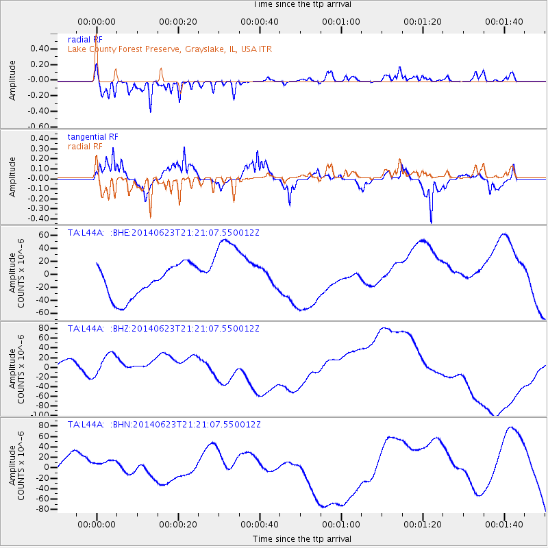
L44A Lake County Forest Preserve, Grayslake, IL, USA - Earthquake Result Viewer
*The percent match for this event was below the threshold and hence no stack was calculated.
| Earthquake location: |
Rat Islands, Aleutian Islands |
| Earthquake latitude/longitude: |
52.0/178.4 |
| Earthquake time(UTC): |
2014/06/23 (174) 21:11:41 GMT |
| Earthquake Depth: |
107 km |
| Earthquake Magnitude: |
6.0 MB |
| Earthquake Catalog/Contributor: |
NEIC PDE/NEIC COMCAT |
|
| Network: |
TA USArray Transportable Network (new EarthScope stations) |
| Station: |
L44A Lake County Forest Preserve, Grayslake, IL, USA |
| Lat/Lon: |
42.18 N/87.91 W |
| Elevation: |
202 m |
|
| Distance: |
60.3 deg |
| Az: |
58.682 deg |
| Baz: |
314.676 deg |
| Ray Param: |
$rayparam |
*The percent match for this event was below the threshold and hence was not used in the summary stack. |
|
| Radial Match: |
90.725586 % |
| Radial Bump: |
258 |
| Transverse Match: |
41.62864 % |
| Transverse Bump: |
261 |
| SOD ConfigId: |
739768 |
| Insert Time: |
2014-07-07 22:43:57.834 +0000 |
| GWidth: |
2.5 |
| Max Bumps: |
400 |
| Tol: |
0.001 |
|
Signal To Noise
| Channel | StoN | STA | LTA |
| TA:L44A: :BHZ:20140623T21:21:07.550012Z | 2.1935303 | 2.8069891E-5 | 1.2796672E-5 |
| TA:L44A: :BHN:20140623T21:21:07.550012Z | 1.3225006 | 2.3927314E-5 | 1.809248E-5 |
| TA:L44A: :BHE:20140623T21:21:07.550012Z | 2.3485587 | 5.7986803E-5 | 2.4690378E-5 |
| Arrivals |
| Ps | |
| PpPs | |
| PsPs/PpSs | |


