You are here: Home > Network List > TA - USArray Transportable Network (new EarthScope stations) Stations List
> Station V60A Jim Taylor Road, Stokes, NC, USA > Earthquake Result Viewer
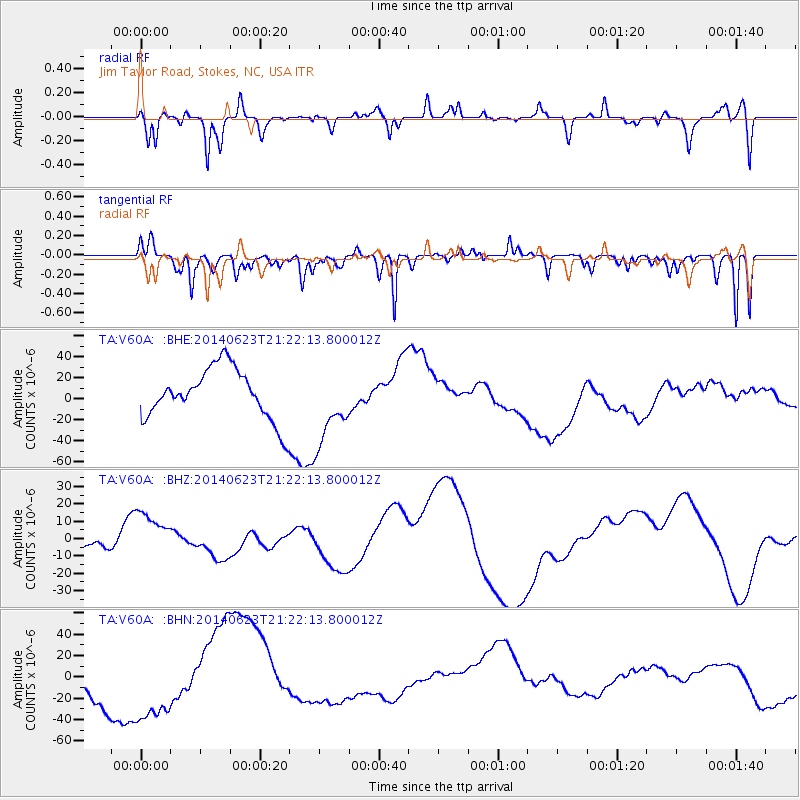
V60A Jim Taylor Road, Stokes, NC, USA - Earthquake Result Viewer
*The percent match for this event was below the threshold and hence no stack was calculated.
| Earthquake location: |
Rat Islands, Aleutian Islands |
| Earthquake latitude/longitude: |
52.0/178.4 |
| Earthquake time(UTC): |
2014/06/23 (174) 21:11:41 GMT |
| Earthquake Depth: |
107 km |
| Earthquake Magnitude: |
6.0 MB |
| Earthquake Catalog/Contributor: |
NEIC PDE/NEIC COMCAT |
|
| Network: |
TA USArray Transportable Network (new EarthScope stations) |
| Station: |
V60A Jim Taylor Road, Stokes, NC, USA |
| Lat/Lon: |
35.76 N/77.26 W |
| Elevation: |
8.0 m |
|
| Distance: |
70.6 deg |
| Az: |
56.675 deg |
| Baz: |
320.531 deg |
| Ray Param: |
$rayparam |
*The percent match for this event was below the threshold and hence was not used in the summary stack. |
|
| Radial Match: |
43.59312 % |
| Radial Bump: |
385 |
| Transverse Match: |
34.392178 % |
| Transverse Bump: |
298 |
| SOD ConfigId: |
739768 |
| Insert Time: |
2014-07-07 22:46:54.248 +0000 |
| GWidth: |
2.5 |
| Max Bumps: |
400 |
| Tol: |
0.001 |
|
Signal To Noise
| Channel | StoN | STA | LTA |
| TA:V60A: :BHZ:20140623T21:22:13.800012Z | 1.9008673 | 1.5186158E-5 | 7.989068E-6 |
| TA:V60A: :BHN:20140623T21:22:13.800012Z | 2.4893236 | 4.09023E-5 | 1.6431091E-5 |
| TA:V60A: :BHE:20140623T21:22:13.800012Z | 1.5089512 | 3.615694E-5 | 2.3961635E-5 |
| Arrivals |
| Ps | |
| PpPs | |
| PsPs/PpSs | |


