You are here: Home > Network List > TA - USArray Transportable Network (new EarthScope stations) Stations List
> Station Y58A Scranton, SC, USA > Earthquake Result Viewer
Y58A Scranton, SC, USA - Earthquake Result Viewer

| Earthquake location: |
Rat Islands, Aleutian Islands |
| Earthquake latitude/longitude: |
52.0/178.4 |
| Earthquake time(UTC): |
2014/06/23 (174) 21:11:41 GMT |
| Earthquake Depth: |
107 km |
| Earthquake Magnitude: |
6.0 MB |
| Earthquake Catalog/Contributor: |
NEIC PDE/NEIC COMCAT |
|
| Network: |
TA USArray Transportable Network (new EarthScope stations) |
| Station: |
Y58A Scranton, SC, USA |
| Lat/Lon: |
33.91 N/79.67 W |
| Elevation: |
19 m |
|
| Distance: |
70.7 deg |
| Az: |
59.543 deg |
| Baz: |
320.114 deg |
| Ray Param: |
0.054517142 |
| Estimated Moho Depth: |
41.75 km |
| Estimated Crust Vp/Vs: |
1.69 |
| Assumed Crust Vp: |
6.24 km/s |
| Estimated Crust Vs: |
3.698 km/s |
| Estimated Crust Poisson's Ratio: |
0.23 |
|
| Radial Match: |
88.46664 % |
| Radial Bump: |
157 |
| Transverse Match: |
35.72555 % |
| Transverse Bump: |
400 |
| SOD ConfigId: |
739768 |
| Insert Time: |
2014-07-07 22:48:05.541 +0000 |
| GWidth: |
2.5 |
| Max Bumps: |
400 |
| Tol: |
0.001 |
|
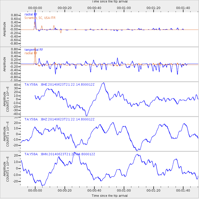
Signal To Noise
| Channel | StoN | STA | LTA |
| TA:Y58A: :BHZ:20140623T21:22:14.800012Z | 1.4428039 | 1.0361812E-5 | 7.1817194E-6 |
| TA:Y58A: :BHN:20140623T21:22:14.800012Z | 3.7851386 | 2.7879512E-5 | 7.3655197E-6 |
| TA:Y58A: :BHE:20140623T21:22:14.800012Z | 2.5408087 | 3.624568E-5 | 1.4265413E-5 |
| Arrivals |
| Ps | 4.8 SECOND |
| PpPs | 17 SECOND |
| PsPs/PpSs | 22 SECOND |


