You are here: Home > Network List > US - United States National Seismic Network Stations List
> Station AMTX Amarillo, Texas, USA > Earthquake Result Viewer
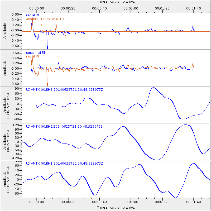
AMTX Amarillo, Texas, USA - Earthquake Result Viewer
*The percent match for this event was below the threshold and hence no stack was calculated.
| Earthquake location: |
Rat Islands, Aleutian Islands |
| Earthquake latitude/longitude: |
52.0/178.4 |
| Earthquake time(UTC): |
2014/06/23 (174) 21:11:41 GMT |
| Earthquake Depth: |
107 km |
| Earthquake Magnitude: |
6.0 MB |
| Earthquake Catalog/Contributor: |
NEIC PDE/NEIC COMCAT |
|
| Network: |
US United States National Seismic Network |
| Station: |
AMTX Amarillo, Texas, USA |
| Lat/Lon: |
34.53 N/101.41 W |
| Elevation: |
1010 m |
|
| Distance: |
58.0 deg |
| Az: |
73.661 deg |
| Baz: |
314.017 deg |
| Ray Param: |
$rayparam |
*The percent match for this event was below the threshold and hence was not used in the summary stack. |
|
| Radial Match: |
93.97385 % |
| Radial Bump: |
400 |
| Transverse Match: |
50.43923 % |
| Transverse Bump: |
400 |
| SOD ConfigId: |
739768 |
| Insert Time: |
2014-07-07 22:49:06.222 +0000 |
| GWidth: |
2.5 |
| Max Bumps: |
400 |
| Tol: |
0.001 |
|
Signal To Noise
| Channel | StoN | STA | LTA |
| US:AMTX:00:BHZ:20140623T21:20:48.923975Z | 1.523535 | 2.2577839E-5 | 1.4819376E-5 |
| US:AMTX:00:BH1:20140623T21:20:48.923975Z | 1.7834721 | 1.9183672E-5 | 1.0756363E-5 |
| US:AMTX:00:BH2:20140623T21:20:48.923975Z | 4.4482894 | 3.0005709E-5 | 6.7454484E-6 |
| Arrivals |
| Ps | |
| PpPs | |
| PsPs/PpSs | |


