You are here: Home > Network List > US - United States National Seismic Network Stations List
> Station COWI Conover, Wisconsin, USA > Earthquake Result Viewer
COWI Conover, Wisconsin, USA - Earthquake Result Viewer
| Earthquake location: |
Rat Islands, Aleutian Islands |
| Earthquake latitude/longitude: |
52.0/178.4 |
| Earthquake time(UTC): |
2014/06/23 (174) 21:11:41 GMT |
| Earthquake Depth: |
107 km |
| Earthquake Magnitude: |
6.0 MB |
| Earthquake Catalog/Contributor: |
NEIC PDE/NEIC COMCAT |
|
| Network: |
US United States National Seismic Network |
| Station: |
COWI Conover, Wisconsin, USA |
| Lat/Lon: |
46.10 N/89.14 W |
| Elevation: |
523 m |
|
| Distance: |
56.9 deg |
| Az: |
56.066 deg |
| Baz: |
312.461 deg |
| Ray Param: |
0.063509 |
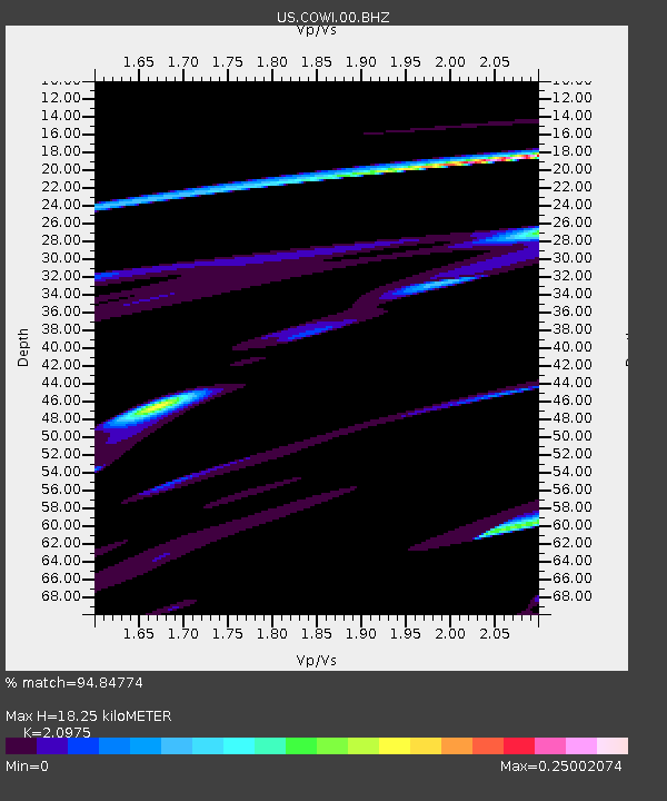
| Estimated Moho Depth: |
18.25 km |
| Estimated Crust Vp/Vs: |
2.10 |
| Assumed Crust Vp: |
6.467 km/s |
| Estimated Crust Vs: |
3.083 km/s |
| Estimated Crust Poisson's Ratio: |
0.35 |
|
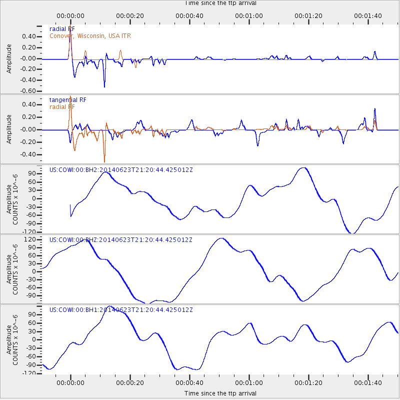
| Radial Match: |
94.84774 % |
| Radial Bump: |
314 |
| Transverse Match: |
45.04164 % |
| Transverse Bump: |
370 |
| SOD ConfigId: |
739768 |
| Insert Time: |
2014-07-07 22:49:22.361 +0000 |
| GWidth: |
2.5 |
| Max Bumps: |
400 |
| Tol: |
0.001 |
|
Signal To Noise
| Channel | StoN | STA | LTA |
| US:COWI:00:BHZ:20140623T21:20:44.425012Z | 2.5528674 | 1.5481058E-4 | 6.0641843E-5 |
| US:COWI:00:BH1:20140623T21:20:44.425012Z | 0.24956363 | 1.2825898E-5 | 5.1393297E-5 |
| US:COWI:00:BH2:20140623T21:20:44.425012Z | 1.7231117 | 6.724605E-5 | 3.9025937E-5 |
| Arrivals |
| Ps | 3.2 SECOND |
| PpPs | 8.4 SECOND |
| PsPs/PpSs | 12 SECOND |


