You are here: Home > Network List > II - Global Seismograph Network (GSN - IRIS/IDA) Stations List
> Station WRAB Tennant Creek, NT, Australia > Earthquake Result Viewer
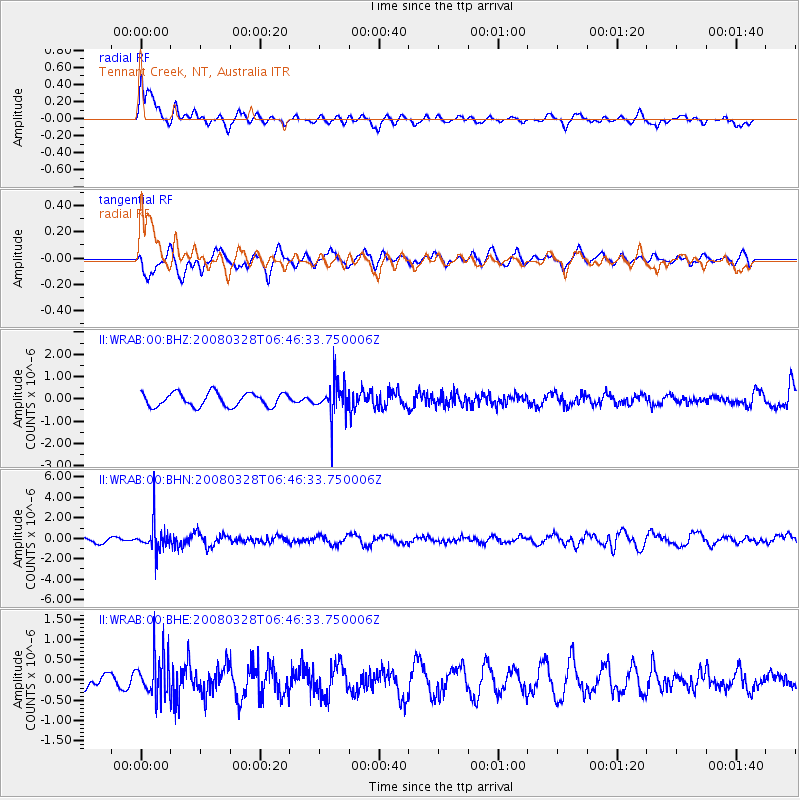
WRAB Tennant Creek, NT, Australia - Earthquake Result Viewer
*The percent match for this event was below the threshold and hence no stack was calculated.
| Earthquake location: |
South Of Kermadec Islands |
| Earthquake latitude/longitude: |
-32.9/179.4 |
| Earthquake time(UTC): |
2008/03/28 (088) 06:39:47 GMT |
| Earthquake Depth: |
365 km |
| Earthquake Magnitude: |
5.6 MW, 5.3 MB, 5.5 MW |
| Earthquake Catalog/Contributor: |
WHDF/NEIC |
|
| Network: |
II Global Seismograph Network (GSN - IRIS/IDA) |
| Station: |
WRAB Tennant Creek, NT, Australia |
| Lat/Lon: |
19.93 S/134.36 E |
| Elevation: |
366 m |
|
| Distance: |
42.0 deg |
| Az: |
276.371 deg |
| Baz: |
117.27 deg |
| Ray Param: |
$rayparam |
*The percent match for this event was below the threshold and hence was not used in the summary stack. |
|
| Radial Match: |
64.32175 % |
| Radial Bump: |
400 |
| Transverse Match: |
70.84101 % |
| Transverse Bump: |
400 |
| SOD ConfigId: |
2504 |
| Insert Time: |
2010-03-01 23:27:37.991 +0000 |
| GWidth: |
2.5 |
| Max Bumps: |
400 |
| Tol: |
0.001 |
|
Signal To Noise
| Channel | StoN | STA | LTA |
| II:WRAB:00:BHN:20080328T06:46:33.750006Z | 4.1012573 | 1.516142E-6 | 3.6967734E-7 |
| II:WRAB:00:BHE:20080328T06:46:33.750006Z | 1.9450828 | 5.143758E-7 | 2.644493E-7 |
| II:WRAB:00:BHZ:20080328T06:46:33.750006Z | 2.723543 | 8.277243E-7 | 3.0391456E-7 |
| Arrivals |
| Ps | |
| PpPs | |
| PsPs/PpSs | |


