You are here: Home > Network List > TA - USArray Transportable Network (new EarthScope stations) Stations List
> Station I23K Minto, Yukon-Koyukuk, AK, USA > Earthquake Result Viewer
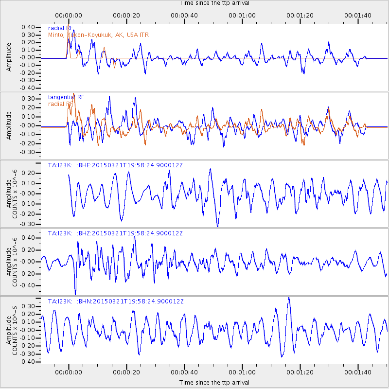
I23K Minto, Yukon-Koyukuk, AK, USA - Earthquake Result Viewer
*The percent match for this event was below the threshold and hence no stack was calculated.
| Earthquake location: |
Talaud Islands, Indonesia |
| Earthquake latitude/longitude: |
3.6/127.4 |
| Earthquake time(UTC): |
2015/03/21 (080) 19:46:31 GMT |
| Earthquake Depth: |
51 km |
| Earthquake Magnitude: |
5.2 MW, 4.5 MS, 5.2 mb |
| Earthquake Catalog/Contributor: |
ISC/ISC |
|
| Network: |
TA USArray Transportable Network (new EarthScope stations) |
| Station: |
I23K Minto, Yukon-Koyukuk, AK, USA |
| Lat/Lon: |
65.15 N/149.36 W |
| Elevation: |
149 m |
|
| Distance: |
83.9 deg |
| Az: |
24.965 deg |
| Baz: |
265.415 deg |
| Ray Param: |
$rayparam |
*The percent match for this event was below the threshold and hence was not used in the summary stack. |
|
| Radial Match: |
61.878853 % |
| Radial Bump: |
400 |
| Transverse Match: |
66.420746 % |
| Transverse Bump: |
400 |
| SOD ConfigId: |
7422571 |
| Insert Time: |
2019-04-17 20:52:32.710 +0000 |
| GWidth: |
2.5 |
| Max Bumps: |
400 |
| Tol: |
0.001 |
|
Signal To Noise
| Channel | StoN | STA | LTA |
| TA:I23K: :BHZ:20150321T19:58:24.900012Z | 2.4820373 | 1.9978977E-7 | 8.049426E-8 |
| TA:I23K: :BHN:20150321T19:58:24.900012Z | 1.0285164 | 1.3355313E-7 | 1.2985026E-7 |
| TA:I23K: :BHE:20150321T19:58:24.900012Z | 0.81786394 | 9.31926E-8 | 1.13946335E-7 |
| Arrivals |
| Ps | |
| PpPs | |
| PsPs/PpSs | |


