You are here: Home > Network List > TA - USArray Transportable Network (new EarthScope stations) Stations List
> Station F49A Sandfield, ON, CAN > Earthquake Result Viewer
F49A Sandfield, ON, CAN - Earthquake Result Viewer
| Earthquake location: |
Rat Islands, Aleutian Islands |
| Earthquake latitude/longitude: |
52.0/178.4 |
| Earthquake time(UTC): |
2014/06/23 (174) 21:30:47 GMT |
| Earthquake Depth: |
109 km |
| Earthquake Magnitude: |
5.9 MB |
| Earthquake Catalog/Contributor: |
NEIC PDE/NEIC COMCAT |
|
| Network: |
TA USArray Transportable Network (new EarthScope stations) |
| Station: |
F49A Sandfield, ON, CAN |
| Lat/Lon: |
45.76 N/82.04 W |
| Elevation: |
230 m |
|
| Distance: |
60.7 deg |
| Az: |
52.309 deg |
| Baz: |
315.66 deg |
| Ray Param: |
0.061029006 |
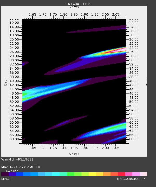
| Estimated Moho Depth: |
24.75 km |
| Estimated Crust Vp/Vs: |
2.10 |
| Assumed Crust Vp: |
6.483 km/s |
| Estimated Crust Vs: |
3.094 km/s |
| Estimated Crust Poisson's Ratio: |
0.35 |
|
| Radial Match: |
93.19681 % |
| Radial Bump: |
400 |
| Transverse Match: |
57.333313 % |
| Transverse Bump: |
396 |
| SOD ConfigId: |
739768 |
| Insert Time: |
2014-07-07 23:14:20.547 +0000 |
| GWidth: |
2.5 |
| Max Bumps: |
400 |
| Tol: |
0.001 |
|
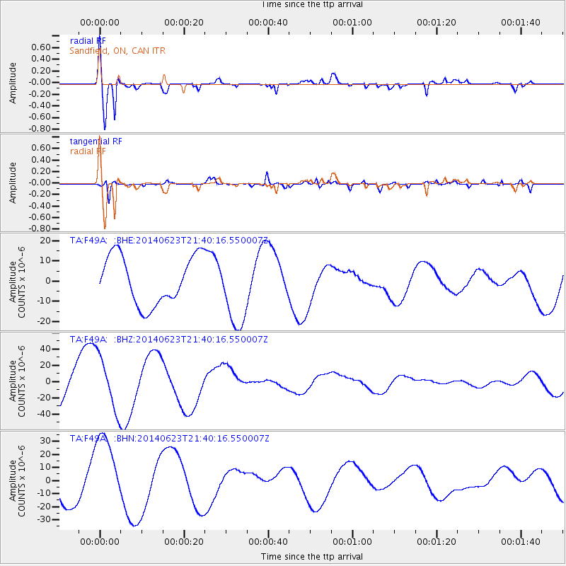
Signal To Noise
| Channel | StoN | STA | LTA |
| TA:F49A: :BHZ:20140623T21:40:16.550007Z | 2.0171041 | 3.312778E-5 | 1.6423435E-5 |
| TA:F49A: :BHN:20140623T21:40:16.550007Z | 2.2349894 | 2.9925488E-5 | 1.3389543E-5 |
| TA:F49A: :BHE:20140623T21:40:16.550007Z | 1.5689417 | 1.8741195E-5 | 1.1945119E-5 |
| Arrivals |
| Ps | 4.3 SECOND |
| PpPs | 11 SECOND |
| PsPs/PpSs | 16 SECOND |


