You are here: Home > Network List > II - Global Seismograph Network (GSN - IRIS/IDA) Stations List
> Station WRAB Tennant Creek, NT, Australia > Earthquake Result Viewer
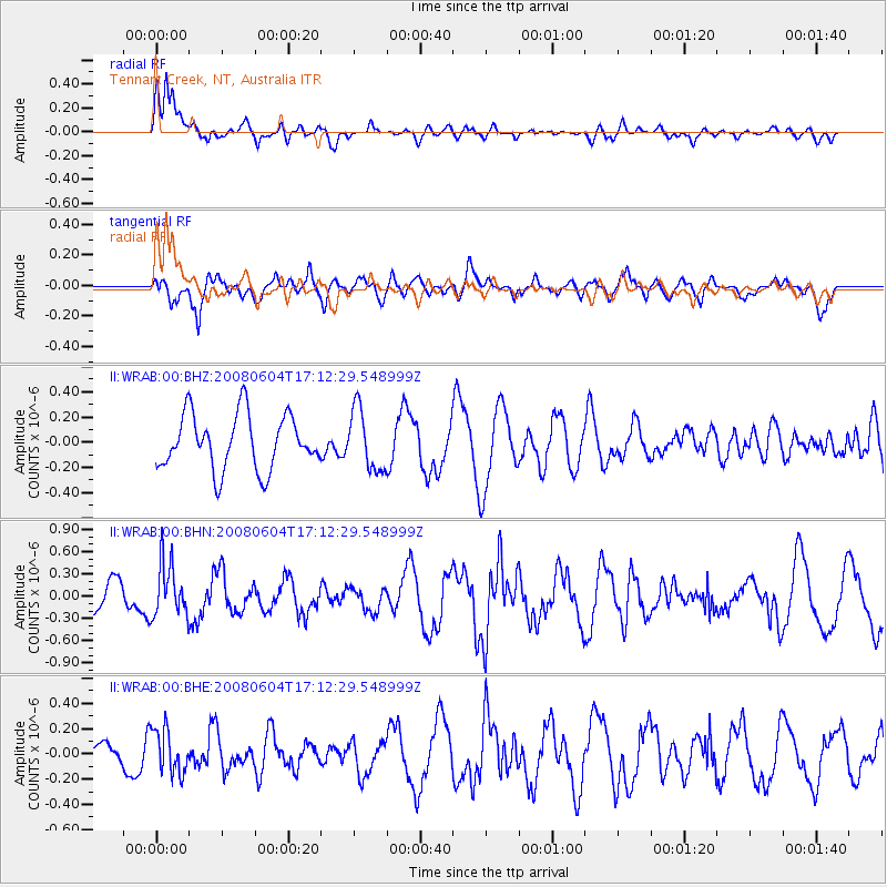
WRAB Tennant Creek, NT, Australia - Earthquake Result Viewer
*The percent match for this event was below the threshold and hence no stack was calculated.
| Earthquake location: |
Hokkaido, Japan Region |
| Earthquake latitude/longitude: |
41.5/139.0 |
| Earthquake time(UTC): |
2008/06/04 (156) 17:03:07 GMT |
| Earthquake Depth: |
213 km |
| Earthquake Magnitude: |
5.5 MB, 5.7 MW, 5.7 MW |
| Earthquake Catalog/Contributor: |
WHDF/NEIC |
|
| Network: |
II Global Seismograph Network (GSN - IRIS/IDA) |
| Station: |
WRAB Tennant Creek, NT, Australia |
| Lat/Lon: |
19.93 S/134.36 E |
| Elevation: |
366 m |
|
| Distance: |
61.3 deg |
| Az: |
185.029 deg |
| Baz: |
4.011 deg |
| Ray Param: |
$rayparam |
*The percent match for this event was below the threshold and hence was not used in the summary stack. |
|
| Radial Match: |
72.6338 % |
| Radial Bump: |
400 |
| Transverse Match: |
54.475803 % |
| Transverse Bump: |
400 |
| SOD ConfigId: |
2504 |
| Insert Time: |
2010-03-01 23:28:05.494 +0000 |
| GWidth: |
2.5 |
| Max Bumps: |
400 |
| Tol: |
0.001 |
|
Signal To Noise
| Channel | StoN | STA | LTA |
| II:WRAB:00:BHN:20080604T17:12:29.548999Z | 2.2543457 | 3.6210102E-7 | 1.6062356E-7 |
| II:WRAB:00:BHE:20080604T17:12:29.548999Z | 1.5814824 | 1.7482837E-7 | 1.1054715E-7 |
| II:WRAB:00:BHZ:20080604T17:12:29.548999Z | 1.1154538 | 2.429358E-7 | 2.1779101E-7 |
| Arrivals |
| Ps | |
| PpPs | |
| PsPs/PpSs | |


