You are here: Home > Network List > US - United States National Seismic Network Stations List
> Station MSO Missoula, Montana, USA > Earthquake Result Viewer
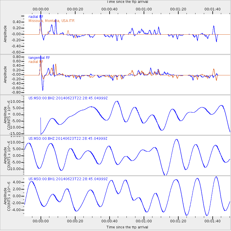
MSO Missoula, Montana, USA - Earthquake Result Viewer
*The percent match for this event was below the threshold and hence no stack was calculated.
| Earthquake location: |
Kermadec Islands, New Zealand |
| Earthquake latitude/longitude: |
-30.2/-177.8 |
| Earthquake time(UTC): |
2014/06/23 (174) 22:15:50 GMT |
| Earthquake Depth: |
10 km |
| Earthquake Magnitude: |
5.5 MB |
| Earthquake Catalog/Contributor: |
NEIC PDE/NEIC COMCAT |
|
| Network: |
US United States National Seismic Network |
| Station: |
MSO Missoula, Montana, USA |
| Lat/Lon: |
46.83 N/113.94 W |
| Elevation: |
1264 m |
|
| Distance: |
95.8 deg |
| Az: |
38.276 deg |
| Baz: |
231.365 deg |
| Ray Param: |
$rayparam |
*The percent match for this event was below the threshold and hence was not used in the summary stack. |
|
| Radial Match: |
70.996445 % |
| Radial Bump: |
389 |
| Transverse Match: |
80.96396 % |
| Transverse Bump: |
400 |
| SOD ConfigId: |
739768 |
| Insert Time: |
2014-07-07 23:41:08.347 +0000 |
| GWidth: |
2.5 |
| Max Bumps: |
400 |
| Tol: |
0.001 |
|
Signal To Noise
| Channel | StoN | STA | LTA |
| US:MSO:00:BHZ:20140623T22:28:45.04999Z | 1.2881608 | 6.314525E-6 | 4.9019695E-6 |
| US:MSO:00:BH1:20140623T22:28:45.04999Z | 1.1054409 | 2.6839818E-6 | 2.427974E-6 |
| US:MSO:00:BH2:20140623T22:28:45.04999Z | 1.7446431 | 8.447219E-6 | 4.841804E-6 |
| Arrivals |
| Ps | |
| PpPs | |
| PsPs/PpSs | |


