You are here: Home > Network List > II - Global Seismograph Network (GSN - IRIS/IDA) Stations List
> Station WRAB Tennant Creek, NT, Australia > Earthquake Result Viewer
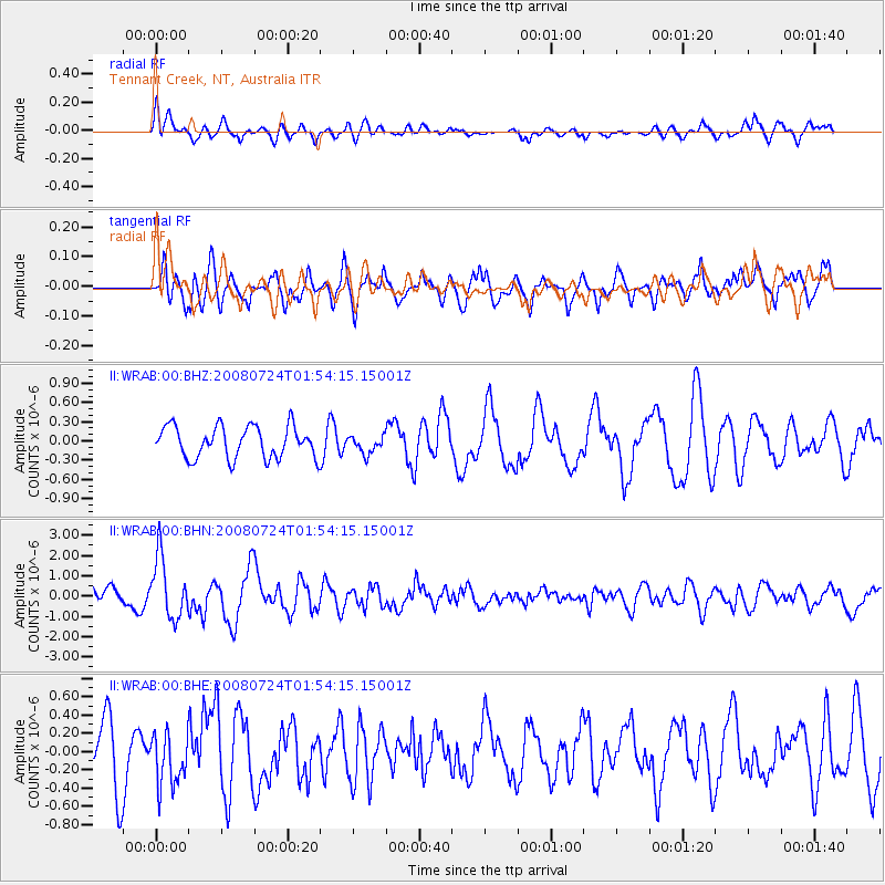
WRAB Tennant Creek, NT, Australia - Earthquake Result Viewer
*The percent match for this event was below the threshold and hence no stack was calculated.
| Earthquake location: |
Kuril Islands |
| Earthquake latitude/longitude: |
51.0/157.6 |
| Earthquake time(UTC): |
2008/07/24 (206) 01:43:16 GMT |
| Earthquake Depth: |
27 km |
| Earthquake Magnitude: |
6.0 MB, 6.0 MS, 6.2 MW, 6.2 MW |
| Earthquake Catalog/Contributor: |
WHDF/NEIC |
|
| Network: |
II Global Seismograph Network (GSN - IRIS/IDA) |
| Station: |
WRAB Tennant Creek, NT, Australia |
| Lat/Lon: |
19.93 S/134.36 E |
| Elevation: |
366 m |
|
| Distance: |
73.5 deg |
| Az: |
202.764 deg |
| Baz: |
15.074 deg |
| Ray Param: |
$rayparam |
*The percent match for this event was below the threshold and hence was not used in the summary stack. |
|
| Radial Match: |
56.933014 % |
| Radial Bump: |
400 |
| Transverse Match: |
67.892845 % |
| Transverse Bump: |
400 |
| SOD ConfigId: |
2504 |
| Insert Time: |
2010-03-01 23:28:21.548 +0000 |
| GWidth: |
2.5 |
| Max Bumps: |
400 |
| Tol: |
0.001 |
|
Signal To Noise
| Channel | StoN | STA | LTA |
| II:WRAB:00:BHN:20080724T01:54:15.15001Z | 4.24777 | 1.5131633E-6 | 3.5622537E-7 |
| II:WRAB:00:BHE:20080724T01:54:15.15001Z | 0.9045447 | 2.8767684E-7 | 3.1803498E-7 |
| II:WRAB:00:BHZ:20080724T01:54:15.15001Z | 0.5622053 | 1.3896218E-7 | 2.4717338E-7 |
| Arrivals |
| Ps | |
| PpPs | |
| PsPs/PpSs | |


