You are here: Home > Network List > II - Global Seismograph Network (GSN - IRIS/IDA) Stations List
> Station WRAB Tennant Creek, NT, Australia > Earthquake Result Viewer
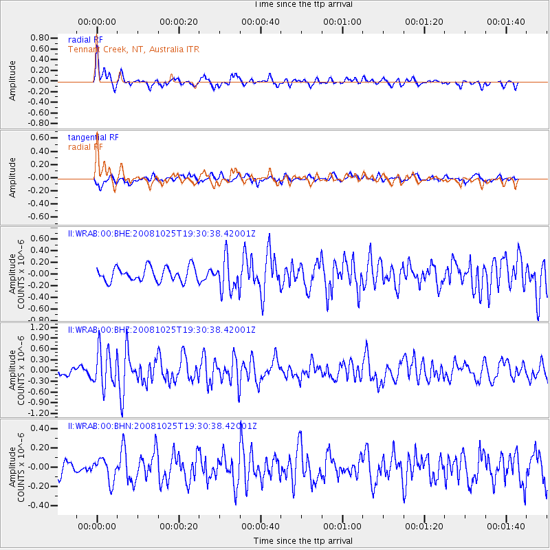
WRAB Tennant Creek, NT, Australia - Earthquake Result Viewer
*The percent match for this event was below the threshold and hence no stack was calculated.
| Earthquake location: |
Vanuatu Islands |
| Earthquake latitude/longitude: |
-17.2/167.3 |
| Earthquake time(UTC): |
2008/10/25 (299) 19:24:50 GMT |
| Earthquake Depth: |
23 km |
| Earthquake Magnitude: |
5.7 MB, 5.3 MS, 5.7 MW, 5.7 MW |
| Earthquake Catalog/Contributor: |
WHDF/NEIC |
|
| Network: |
II Global Seismograph Network (GSN - IRIS/IDA) |
| Station: |
WRAB Tennant Creek, NT, Australia |
| Lat/Lon: |
19.93 S/134.36 E |
| Elevation: |
366 m |
|
| Distance: |
31.3 deg |
| Az: |
259.862 deg |
| Baz: |
90.548 deg |
| Ray Param: |
$rayparam |
*The percent match for this event was below the threshold and hence was not used in the summary stack. |
|
| Radial Match: |
78.19567 % |
| Radial Bump: |
400 |
| Transverse Match: |
67.21764 % |
| Transverse Bump: |
400 |
| SOD ConfigId: |
2556 |
| Insert Time: |
2010-03-01 23:28:30.317 +0000 |
| GWidth: |
2.5 |
| Max Bumps: |
400 |
| Tol: |
0.001 |
|
Signal To Noise
| Channel | StoN | STA | LTA |
| II:WRAB:00:BHZ:20081025T19:30:38.42001Z | 2.6856704 | 5.300871E-7 | 1.973761E-7 |
| II:WRAB:00:BHN:20081025T19:30:38.42001Z | 0.8823182 | 1.2225813E-7 | 1.3856467E-7 |
| II:WRAB:00:BHE:20081025T19:30:38.42001Z | 2.4028986 | 2.8934858E-7 | 1.2041647E-7 |
| Arrivals |
| Ps | |
| PpPs | |
| PsPs/PpSs | |


